Gonzales Ortega geodata
Gonzales Ortega (Zacatecas) is a populated place; located in Mexico in America/Mexico_City (GMT-6) time zone. With population of 4,137 people, there are 2214 cities with bigger population in this country. Compared to other cities in Mexico, 88.3% of cities are located further ↓South; 83.9% of cities are located further →East and 75.6% of cities have lower elevation than Gonzales Ortega. Note1


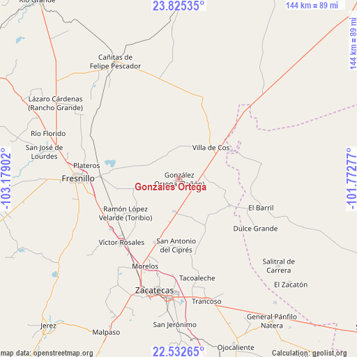
Gonzales Ortega GPS coordinates[2]
23° 10' 50.016" North, 102° 28' 33.204" West
| Map corner | latitude | longitude |
|---|---|---|
| Upper-left | 23.82535°, | -103.17902° |
| Center: | 23.18056°, | -102.47589° |
| Lower-right: | 22.53265°, | -101.77277° |
| Map W x H: | 143.7×143.7 km | = 89.3×89.3mi |
| max Lat: | 32.7° ⇑11.7% North |
| Gonzales Ortega: | 23.18056° |
| min Lat: | ⇓88.3% South 14.53588° |
| min Long | Gonzales Ortega | max Long |
| -117.105° | -102.47589° | -86.73105° |
| W 16.1%⇐ | ⇒83.9% E |
Elevation
Elevation of Gonzales Ortega is 2042 m = 6699 ft, and this is 788.3 m = 2586 ft above average elevation for this country.
| Max E: |
3497 m = 11473 ft | 24.4% |
| Gonzales Ortega | 2042 m 6699 ft | |
| Avg. | 1253.7 m = 4113 ft | |
Min E: |
-1 m = -3 ft | 75.6% |
See also: Mexico elevation on elevation.city.
Geographical zone
Gonzales Ortega is located in North Torrid zone (between Equator and Tropic of Cancer). Distance of this Northern Tropic circle is 28.5 km =17.7 mi to North.| Distance of | km | miles | from Gonzales Ortega |
|---|---|---|---|
| North Pole | 7429.6 | 4616.5 | to North |
| Arctic Circle | 4823.7 | 2997.3 | to North |
| Tropic Cancer | 28.5 | 17.7 | to North |
| Equator | 2577.4 | 1601.5 | to South |


Nearby cities:
15 places around Gonzales Ortega: (largest is in red/bold)
• Chaparrosa
23 km =14.3 mi,  118°
118°
• Chichimequillas
12.3 km =7.6 mi,  301°
301°
• Chupaderos
15.6 km =9.7 mi,  98°
98°
• Hacienda Toribio
23.8 km =14.8 mi,  242°
242°
• Jesús María
29.1 km =18.1 mi, 95°
• Laguna Seca
13.4 km =8.3 mi,  188°
188°
• Las Catarinas
17.4 km =10.8 mi, 235°
• Los Pozos
20.4 km =12.7 mi,  184°
184°
• Pozos de Gamboa
27.5 km =17.1 mi,  200°
200°
• Rafael Yáñez Sosa (El Mezquite)
21.4 km =13.3 mi,  320°
320°
• San Antonio del Cipres
26.9 km =16.7 mi, 182°
• San Juan
20.9 km =13 mi,  152°
152°
• San Ramón
5.8 km =3.6 mi, 124°
• Santiaguillo
18.4 km =11.4 mi,  258°
258°
• Villa de Cos
17.9 km =11.1 mi,  45°
45°
Sources, notices
• [Note1] Compared only with cities in Mexico existing in our database
• [Src1] Map data: © OpenStreetMap contributors (CC-BY-SA)
• [Src2] Other city data from geonames.org with taken over terms of usage.
• [Src3] Geographical zone / Annual Mean Temperature by Robert A. Rohde @ Wikipedia
