San Ramón geodata
San Ramón (Zacatecas) is a populated place; located in Mexico in America/Mexico_City (GMT-6) time zone. With population of 533 people, there are 15888 cities with bigger population in this country. Compared to other cities in Mexico, 88.3% of cities are located further ↓South; 83.7% of cities are located further →East and 73.3% of cities have lower elevation than San Ramón. Note1


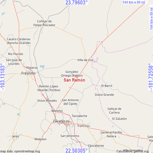
San Ramón GPS coordinates[2]
23° 9' 3.96" North, 102° 25' 43.32" West
| Map corner | latitude | longitude |
|---|---|---|
| Upper-left | 23.79603°, | -103.13183° |
| Center: | 23.1511°, | -102.4287° |
| Lower-right: | 22.50305°, | -101.72558° |
| Map W x H: | 143.8×143.8 km | = 89.4×89.4mi |
| max Lat: | 32.7° ⇑11.7% North |
| San Ramón: | 23.1511° |
| min Lat: | ⇓88.3% South 14.53588° |
| min Long | San Ramón | max Long |
| -117.105° | -102.4287° | -86.73105° |
| W 16.3%⇐ | ⇒83.7% E |
Elevation
Elevation of San Ramón is 1996 m = 6549 ft, and this is 742.3 m = 2435 ft above average elevation for this country.
| Max E: |
3497 m = 11473 ft | 26.7% |
| San Ramón | 1996 m 6549 ft | |
| Avg. | 1253.7 m = 4113 ft | |
Min E: |
-1 m = -3 ft | 73.3% |
See also: Mexico elevation on elevation.city.
Geographical zone
San Ramón is located in North Torrid zone (between Equator and Tropic of Cancer). Distance of this Northern Tropic circle is 31.8 km =19.8 mi to North.| Distance of | km | miles | from San Ramón |
|---|---|---|---|
| North Pole | 7432.9 | 4618.6 | to North |
| Arctic Circle | 4827 | 2999.4 | to North |
| Tropic Cancer | 31.8 | 19.8 | to North |
| Equator | 2574.2 | 1599.5 | to South |


Nearby cities:
15 places around San Ramón: (largest is in red/bold)
• Chaparrosa
17.2 km =10.7 mi,  115°
115°
• Chichimequillas
18.2 km =11.3 mi,  302°
302°
• Chupaderos
10.6 km =6.6 mi,  85°
85°
• Gonzales Ortega
5.8 km =3.6 mi, 304°
• Hacienda Toribio
27.1 km =16.8 mi,  253°
253°
• Jesús María
24.1 km =15 mi, 89°
• Laguna Seca
12.1 km =7.5 mi,  214°
214°
• Las Catarinas
20.3 km =12.6 mi, 250°
• Los Pozos
18.2 km =11.3 mi,  200°
200°
• Pozos de Gamboa
26.8 km =16.7 mi, 212°
• San Antonio del Cipres
24.4 km =15.2 mi,  194°
194°
• San Juan
16 km =9.9 mi,  162°
162°
• Santa Rita
26.6 km =16.5 mi,  177°
177°
• Santiaguillo
22.9 km =14.2 mi,  268°
268°
• Villa de Cos
17.7 km =11 mi,  26°
26°
Sources, notices
• [Note1] Compared only with cities in Mexico existing in our database
• [Src1] Map data: © OpenStreetMap contributors (CC-BY-SA)
• [Src2] Other city data from geonames.org with taken over terms of usage.
• [Src3] Geographical zone / Annual Mean Temperature by Robert A. Rohde @ Wikipedia
