San Rafael de los Moreno geodata
San Rafael de los Moreno (Jalisco) is a populated place; located in Mexico in America/Mexico_City (GMT-6) time zone. With population of 700 people, there are 12436 cities with bigger population in this country. Compared to other cities in Mexico, 59.6% of cities are located further ↓South; 92.3% of cities are located further →East and 77.2% of cities have higher elevation than San Rafael de los Moreno. Note1
Current local time in San Rafael de los Moreno:
12:46 AM, WednesdayDifference from your time zone: hours


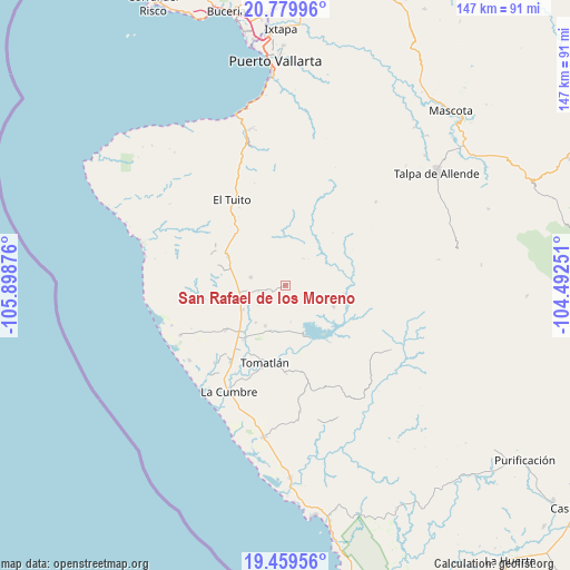
San Rafael de los Moreno GPS coordinates[2]
20° 7' 16.14" North, 105° 11' 44.268" West
| Map corner | latitude | longitude |
|---|---|---|
| Upper-left | 20.77996°, | -105.89876° |
| Center: | 20.12115°, | -105.19563° |
| Lower-right: | 19.45956°, | -104.49251° |
| Map W x H: | 146.8×146.8 km | = 91.2×91.2mi |
| max Lat: | 32.7° ⇑40.4% North |
| San Rafael de los Moreno: | 20.12115° |
| min Lat: | ⇓59.6% South 14.53588° |
| min Long | San Rafael de l | max Long |
| -117.105° | -105.19563° | -86.73105° |
| W 7.7%⇐ | ⇒92.3% E |
Elevation
Elevation of San Rafael de los Moreno is 148 m = 486 ft, and this is 1105.7 m = 3628 ft below average elevation for this country.
| Max E: |
3497 m = 11473 ft | 77.2% |
| Avg. | 1253.7 m = 4113 ft | |
| San Rafael de los Moreno | 148 m = 486 ft | |
Min E: |
-1 m = -3 ft | 22.8% |
See also: Mexico elevation on elevation.city.
Geographical zone
San Rafael de los Moreno is located in North Torrid zone (between Equator and Tropic of Cancer). Distance of this Northern Tropic circle is 368.7 km =229.1 mi to North.| Distance of | km | miles | from San Rafael de los Moreno |
|---|---|---|---|
| North Pole | 7769.8 | 4827.9 | to North |
| Arctic Circle | 5163.9 | 3208.7 | to North |
| Tropic Cancer | 368.7 | 229.1 | to North |
| Equator | 2237.3 | 1390.2 | to South |


Nearby cities:
15 places around San Rafael de los Moreno: (largest is in red/bold)
• Boca de Tomatlán
45.3 km =28.1 mi,  344°
344°
• Campo Acosta
39.4 km =24.5 mi,  188°
188°
• El Tequesquite
12.6 km =7.8 mi,  240°
240°
• El Tuito
25.9 km =16.1 mi,  328°
328°
• El Tule
11.5 km =7.1 mi,  206°
206°
• Gargantillo
19.5 km =12.1 mi,  233°
233°
• José María Pino Suárez (Nuevo Nahuapa)
23.6 km =14.7 mi,  215°
215°
• La Cruz de Loreto
29.9 km =18.6 mi,  245°
245°
• La Cumbre
30.8 km =19.1 mi, 207°
• La Gloria
27.1 km =16.8 mi, 222°
• Las Juntas y los Veranos
41.2 km =25.6 mi,  345°
345°
• Llano Grande
34.8 km =21.6 mi,  105°
105°
• Llano de los Laureles
24.2 km =15 mi, 329°
• Lázaro Cárdenas
32.8 km =20.4 mi,  173°
173°
• Tomatlán
21.3 km =13.2 mi,  195°
195°
Sources, notices
• [Note1] Compared only with cities in Mexico existing in our database
• [Src1] Map data: © OpenStreetMap contributors (CC-BY-SA)
• [Src2] Other city data from geonames.org with taken over terms of usage.
• [Src3] Geographical zone / Annual Mean Temperature by Robert A. Rohde @ Wikipedia
