El Tequesquite geodata
El Tequesquite (Jalisco) is a populated place; located in Mexico in America/Mexico_City (GMT-6) time zone. With population of 1,172 people, there are 7412 cities with bigger population in this country. Compared to other cities in Mexico, 58.5% of cities are located further ↓South; 92.7% of cities are located further →East and 81.4% of cities have higher elevation than El Tequesquite. Note1


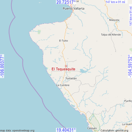
El Tequesquite GPS coordinates[2]
20° 3' 58.068" North, 105° 18' 2.304" West
| Map corner | latitude | longitude |
|---|---|---|
| Upper-left | 20.72517°, | -106.00377° |
| Center: | 20.06613°, | -105.30064° |
| Lower-right: | 19.40431°, | -104.59752° |
| Map W x H: | 146.9×146.9 km | = 91.3×91.3mi |
| max Lat: | 32.7° ⇑41.5% North |
| El Tequesquite: | 20.06613° |
| min Lat: | ⇓58.5% South 14.53588° |
| min Long | El Tequesquite | max Long |
| -117.105° | -105.30064° | -86.73105° |
| W 7.3%⇐ | ⇒92.7% E |
Elevation
Elevation of El Tequesquite is 77 m = 253 ft, and this is 1176.7 m = 3861 ft below average elevation for this country.
| Max E: |
3497 m = 11473 ft | 81.4% |
| Avg. | 1253.7 m = 4113 ft | |
| El Tequesquite | 77 m = 253 ft | |
Min E: |
-1 m = -3 ft | 18.6% |
See also: Mexico elevation on elevation.city.
Geographical zone
El Tequesquite is located in North Torrid zone (between Equator and Tropic of Cancer). Distance of this Northern Tropic circle is 374.8 km =232.9 mi to North.| Distance of | km | miles | from El Tequesquite |
|---|---|---|---|
| North Pole | 7775.9 | 4831.7 | to North |
| Arctic Circle | 5170 | 3212.5 | to North |
| Tropic Cancer | 374.8 | 232.9 | to North |
| Equator | 2231.1 | 1386.3 | to South |


Nearby cities:
15 places around El Tequesquite: (largest is in red/bold)
• Campo Acosta
33.3 km =20.7 mi,  170°
170°
• El Tuito
28.4 km =17.6 mi,  354°
354°
• El Tule
7.3 km =4.5 mi,  125°
125°
• Gargantillo
7.2 km =4.5 mi,  221°
221°
• José María Morelos
44.8 km =27.8 mi,  164°
164°
• José María Pino Suárez (Nuevo Nahuapa)
13.3 km =8.3 mi,  192°
192°
• La Cruz de Loreto
17.4 km =10.8 mi,  248°
248°
• La Cumbre
21.4 km =13.3 mi, 188°
• La Gloria
15.6 km =9.7 mi,  208°
208°
• Las Juntas y los Veranos
46 km =28.6 mi,  0°
0°
• Llano Grande
44.6 km =27.7 mi,  94°
94°
• Llano de los Laureles
27 km =16.8 mi,  357°
357°
• Lázaro Cárdenas
30.3 km =18.8 mi,  150°
150°
• San Rafael de los Moreno
12.6 km =7.8 mi,  60°
60°
• Tomatlán
15.3 km =9.5 mi, 159°
Sources, notices
• [Note1] Compared only with cities in Mexico existing in our database
• [Src1] Map data: © OpenStreetMap contributors (CC-BY-SA)
• [Src2] Other city data from geonames.org with taken over terms of usage.
• [Src3] Geographical zone / Annual Mean Temperature by Robert A. Rohde @ Wikipedia
