La Gloria geodata
La Gloria (Jalisco) is a populated place; located in Mexico in America/Mexico_City (GMT-6) time zone. With population of 767 people, there are 11411 cities with bigger population in this country. Compared to other cities in Mexico, 55.9% of cities are located further ↓South; 92.9% of cities are located further →East and 92.1% of cities have higher elevation than La Gloria. Note1


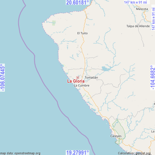
La Gloria GPS coordinates[2]
19° 56' 32.064" North, 105° 22' 16.752" West
| Map corner | latitude | longitude |
|---|---|---|
| Upper-left | 20.60181°, | -106.07445° |
| Center: | 19.94224°, | -105.37132° |
| Lower-right: | 19.27991°, | -104.6682° |
| Map W x H: | 147×147 km | = 91.3×91.3mi |
| max Lat: | 32.7° ⇑44.1% North |
| La Gloria: | 19.94224° |
| min Lat: | ⇓55.9% South 14.53588° |
| min Long | La Gloria | max Long |
| -117.105° | -105.37132° | -86.73105° |
| W 7.1%⇐ | ⇒92.9% E |
Elevation
Elevation of La Gloria is 19 m = 62 ft, and this is 1234.7 m = 4051 ft below average elevation for this country.
| Max E: |
3497 m = 11473 ft | 92.1% |
| Avg. | 1253.7 m = 4113 ft | |
| La Gloria | 19 m = 62 ft | |
Min E: |
-1 m = -3 ft | 7.9% |
See also: Mexico elevation on elevation.city.
Geographical zone
La Gloria is located in North Torrid zone (between Equator and Tropic of Cancer). Distance of this Northern Tropic circle is 388.5 km =241.4 mi to North.| Distance of | km | miles | from La Gloria |
|---|---|---|---|
| North Pole | 7789.7 | 4840.3 | to North |
| Arctic Circle | 5183.8 | 3221.1 | to North |
| Tropic Cancer | 388.5 | 241.4 | to North |
| Equator | 2217.4 | 1377.8 | to South |


Nearby cities:
15 places around La Gloria: (largest is in red/bold)
• Campo Acosta
23 km =14.3 mi,  146°
146°
• El Tequesquite
15.6 km =9.7 mi,  28°
28°
• El Tuito
42.3 km =26.3 mi,  6°
6°
• El Tule
16.4 km =10.2 mi,  54°
54°
• Gargantillo
8.8 km =5.5 mi,  17°
17°
• José María Morelos
35.3 km =21.9 mi, 146°
• José María Pino Suárez (Nuevo Nahuapa)
4.6 km =2.9 mi,  80°
80°
• La Cruz de Loreto
11.4 km =7.1 mi,  309°
309°
• La Cumbre
8.4 km =5.2 mi, 151°
• Llano de los Laureles
41.2 km =25.6 mi, 8°
• Lázaro Cárdenas
25.5 km =15.8 mi,  119°
119°
• Perula
46.7 km =29 mi, 146°
• San Mateo
50.3 km =31.3 mi,  143°
143°
• San Rafael de los Moreno
27.1 km =16.8 mi,  42°
42°
• Tomatlán
12.7 km =7.9 mi,  92°
92°
Sources, notices
• [Note1] Compared only with cities in Mexico existing in our database
• [Src1] Map data: © OpenStreetMap contributors (CC-BY-SA)
• [Src2] Other city data from geonames.org with taken over terms of usage.
• [Src3] Geographical zone / Annual Mean Temperature by Robert A. Rohde @ Wikipedia
