La Aurora geodata
La Aurora (Guanajuato) is a populated place; located in Mexico in America/Mexico_City (GMT-6) time zone. With population of 2,605 people, there are 3403 cities with bigger population in this country. Compared to other cities in Mexico, 70.5% of cities are located further ↓South; 71.5% of cities are located further →East and 63% of cities have lower elevation than La Aurora. Note1


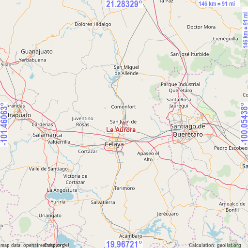
La Aurora GPS coordinates[2]
20° 37' 36.012" North, 100° 45' 27" West
| Map corner | latitude | longitude |
|---|---|---|
| Upper-left | 21.28329°, | -101.46063° |
| Center: | 20.62667°, | -100.7575° |
| Lower-right: | 19.96721°, | -100.05438° |
| Map W x H: | 146.3×146.3 km | = 90.9×90.9mi |
| max Lat: | 32.7° ⇑29.5% North |
| La Aurora: | 20.62667° |
| min Lat: | ⇓70.5% South 14.53588° |
| min Long | La Aurora | max Long |
| -117.105° | -100.7575° | -86.73105° |
| W 28.5%⇐ | ⇒71.5% E |
Elevation
Elevation of La Aurora is 1778 m = 5833 ft, and this is 524.3 m = 1720 ft above average elevation for this country.
| Max E: |
3497 m = 11473 ft | 37% |
| La Aurora | 1778 m 5833 ft | |
| Avg. | 1253.7 m = 4113 ft | |
Min E: |
-1 m = -3 ft | 63% |
See also: Mexico elevation on elevation.city.
Geographical zone
La Aurora is located in North Torrid zone (between Equator and Tropic of Cancer). Distance of this Northern Tropic circle is 312.4 km =194.1 mi to North.| Distance of | km | miles | from La Aurora |
|---|---|---|---|
| North Pole | 7713.6 | 4793 | to North |
| Arctic Circle | 5107.7 | 3173.8 | to North |
| Tropic Cancer | 312.4 | 194.1 | to North |
| Equator | 2293.5 | 1425.1 | to South |


Nearby cities:
15 places around La Aurora: (largest is in red/bold)
• Colonia Luis Donaldo Colosio
6.7 km =4.2 mi,  186°
186°
• Empalme Escobedo
5.2 km =3.2 mi,  12°
12°
• Galvanes
5.5 km =3.4 mi,  62°
62°
• Guadalupe
3.2 km =2 mi,  17°
17°
• Jauregui
5.5 km =3.4 mi,  133°
133°
• La Concepción
4.1 km =2.5 mi,  252°
252°
• Plancarte
6 km =3.7 mi,  222°
222°
• Presa Blanca
4 km =2.5 mi,  294°
294°
• San Antonio Espinoza
4.9 km =3 mi,  305°
305°
• San Antonio Gallardo
1.1 km =0.7 mi,  279°
279°
• San Isidro de la Concepción
2.9 km =1.8 mi,  272°
272°
• San José de la Presa
1.8 km =1.1 mi,  162°
162°
• San Juan de la Vega
0.4 km =0.2 mi, 248°
• San Miguel Octopan
5.9 km =3.7 mi,  170°
170°
• Tenería del Santuario
5.2 km =3.2 mi,  234°
234°
Sources, notices
• [Note1] Compared only with cities in Mexico existing in our database
• [Src1] Map data: © OpenStreetMap contributors (CC-BY-SA)
• [Src2] Other city data from geonames.org with taken over terms of usage.
• [Src3] Geographical zone / Annual Mean Temperature by Robert A. Rohde @ Wikipedia
