San Miguel el Alto geodata
San Miguel el Alto (Jalisco) is a seat of a second-order administrative division; located in Mexico in America/Mexico_City (GMT-6) time zone. With population of 23,982 people, there are 424 cities with bigger population in this country. Compared to other cities in Mexico, 76.9% of cities are located further ↓South; 83.5% of cities are located further →East and 66% of cities have lower elevation than San Miguel el Alto. Note1


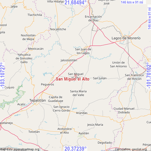
San Miguel el Alto GPS coordinates[2]
21° 1' 48.396" North, 102° 24' 14.904" West
| Map corner | latitude | longitude |
|---|---|---|
| Upper-left | 21.68494°, | -103.10727° |
| Center: | 21.03011°, | -102.40414° |
| Lower-right: | 20.37239°, | -101.70102° |
| Map W x H: | 145.9×145.9 km | = 90.7×90.7mi |
| max Lat: | 32.7° ⇑23.1% North |
| San Miguel el Alto: | 21.03011° |
| min Lat: | ⇓76.9% South 14.53588° |
| min Long | San Miguel el A | max Long |
| -117.105° | -102.40414° | -86.73105° |
| W 16.5%⇐ | ⇒83.5% E |
Elevation
Elevation of San Miguel el Alto is 1851 m = 6073 ft, and this is 597.3 m = 1960 ft above average elevation for this country.
| Max E: |
3497 m = 11473 ft | 34% |
| San Miguel el Alto | 1851 m 6073 ft | |
| Avg. | 1253.7 m = 4113 ft | |
Min E: |
-1 m = -3 ft | 66% |
See also: Mexico elevation on elevation.city.
Geographical zone
San Miguel el Alto is located in North Torrid zone (between Equator and Tropic of Cancer). Distance of this Northern Tropic circle is 267.6 km =166.3 mi to North.| Distance of | km | miles | from San Miguel el Alto |
|---|---|---|---|
| North Pole | 7668.7 | 4765.1 | to North |
| Arctic Circle | 5062.8 | 3145.9 | to North |
| Tropic Cancer | 267.6 | 166.3 | to North |
| Equator | 2338.3 | 1453 | to South |


Nearby cities:
15 places around San Miguel el Alto: (largest is in red/bold)
• Capilla de Guadalupe
29.8 km =18.5 mi,  220°
220°
• Colonia Santa Cecilia (La Sauceda)
25.3 km =15.7 mi,  12°
12°
• Colonia Veintitrés de Mayo
21.5 km =13.4 mi,  95°
95°
• Jalostotitlán
16.5 km =10.3 mi,  337°
337°
• La Calera [Fraccionamiento]
27.4 km =17 mi, 14°
• Los Dolores
28.3 km =17.6 mi,  207°
207°
• Mezquitic de la Magdalena
23.6 km =14.7 mi,  25°
25°
• Pegueros
28.6 km =17.8 mi,  252°
252°
• San José de los Reynoso
13.3 km =8.3 mi,  69°
69°
• San Juan de los Lagos
25.5 km =15.8 mi,  17°
17°
• San Julián
23.4 km =14.5 mi, 95°
• Santa María del Valle
17.1 km =10.6 mi,  171°
171°
• Solidaridad [Fraccionamiento]
17.5 km =10.9 mi, 335°
• Teocaltitan
12.5 km =7.8 mi,  3°
3°
• Valle de Guadalupe
22.2 km =13.8 mi,  264°
264°
Sources, notices
• [Note1] Compared only with cities in Mexico existing in our database
• [Src1] Map data: © OpenStreetMap contributors (CC-BY-SA)
• [Src2] Other city data from geonames.org with taken over terms of usage.
• [Src3] Geographical zone / Annual Mean Temperature by Robert A. Rohde @ Wikipedia
