Pegueros geodata
Pegueros (Jalisco) is a populated place; located in Mexico in America/Mexico_City (GMT-6) time zone. With population of 4,063 people, there are 2243 cities with bigger population in this country. Compared to other cities in Mexico, 75.8% of cities are located further ↓South; 84.7% of cities are located further →East and 67.9% of cities have lower elevation than Pegueros. Note1


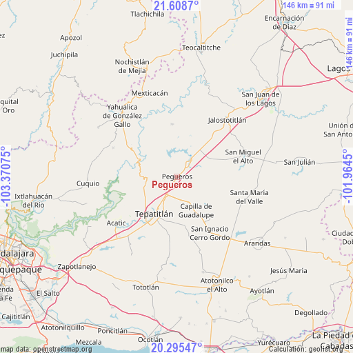
Pegueros GPS coordinates[2]
20° 57' 12.708" North, 102° 40' 3.432" West
| Map corner | latitude | longitude |
|---|---|---|
| Upper-left | 21.6087°, | -103.37075° |
| Center: | 20.95353°, | -102.66762° |
| Lower-right: | 20.29547°, | -101.9645° |
| Map W x H: | 146×146 km | = 90.7×90.7mi |
| max Lat: | 32.7° ⇑24.2% North |
| Pegueros: | 20.95353° |
| min Lat: | ⇓75.8% South 14.53588° |
| min Long | Pegueros | max Long |
| -117.105° | -102.66762° | -86.73105° |
| W 15.3%⇐ | ⇒84.7% E |
Elevation
Elevation of Pegueros is 1888 m = 6194 ft, and this is 634.3 m = 2081 ft above average elevation for this country.
| Max E: |
3497 m = 11473 ft | 32.1% |
| Pegueros | 1888 m 6194 ft | |
| Avg. | 1253.7 m = 4113 ft | |
Min E: |
-1 m = -3 ft | 67.9% |
See also: Mexico elevation on elevation.city.
Geographical zone
Pegueros is located in North Torrid zone (between Equator and Tropic of Cancer). Distance of this Northern Tropic circle is 276.1 km =171.6 mi to North.| Distance of | km | miles | from Pegueros |
|---|---|---|---|
| North Pole | 7677.2 | 4770.4 | to North |
| Arctic Circle | 5071.4 | 3151.2 | to North |
| Tropic Cancer | 276.1 | 171.6 | to North |
| Equator | 2329.8 | 1447.7 | to South |


Nearby cities:
15 places around Pegueros: (largest is in red/bold)
• Capilla de Guadalupe
16.1 km =10 mi,  150°
150°
• Cañadas de Obregón
21.9 km =13.6 mi,  354°
354°
• El Zapote
22.8 km =14.2 mi,  321°
321°
• Jalostotitlán
31.8 km =19.8 mi,  41°
41°
• La Loma (Loma de Enmedio)
18.8 km =11.7 mi,  203°
203°
• Los Dolores
21.9 km =13.6 mi,  139°
139°
• Manalisco
28.9 km =18 mi,  294°
294°
• Mezcala
18.5 km =11.5 mi,  269°
269°
• Ojo de Agua de Latillas
31.7 km =19.7 mi,  185°
185°
• San Ignacio Cerro Gordo
26.9 km =16.7 mi, 149°
• San Miguel el Alto
28.6 km =17.8 mi,  72°
72°
• Santa María del Valle
31 km =19.3 mi,  105°
105°
• Solidaridad [Fraccionamiento]
31.6 km =19.6 mi, 39°
• Tepatitlán de Morelos
18.2 km =11.3 mi,  213°
213°
• Valle de Guadalupe
8.3 km =5.2 mi, 39°
Sources, notices
• [Note1] Compared only with cities in Mexico existing in our database
• [Src1] Map data: © OpenStreetMap contributors (CC-BY-SA)
• [Src2] Other city data from geonames.org with taken over terms of usage.
• [Src3] Geographical zone / Annual Mean Temperature by Robert A. Rohde @ Wikipedia
