Valle de Guadalupe geodata
Valle de Guadalupe (Jalisco) is a seat of a second-order administrative division; located in Mexico in America/Mexico_City (GMT-6) time zone. With population of 4,492 people, there are 2050 cities with bigger population in this country. Compared to other cities in Mexico, 76.6% of cities are located further ↓South; 84.5% of cities are located further →East and 64.9% of cities have lower elevation than Valle de Guadalupe. Note1


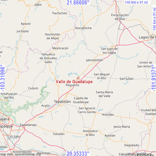
Valle de Guadalupe GPS coordinates[2]
21° 0' 40.104" North, 102° 37' 0.588" West
| Map corner | latitude | longitude |
|---|---|---|
| Upper-left | 21.66606°, | -103.31996° |
| Center: | 21.01114°, | -102.61683° |
| Lower-right: | 20.35333°, | -101.91371° |
| Map W x H: | 146×146 km | = 90.7×90.7mi |
| max Lat: | 32.7° ⇑23.4% North |
| Valle de Guadalupe: | 21.01114° |
| min Lat: | ⇓76.6% South 14.53588° |
| min Long | Valle de Guadal | max Long |
| -117.105° | -102.61683° | -86.73105° |
| W 15.5%⇐ | ⇒84.5% E |
Elevation
Elevation of Valle de Guadalupe is 1826 m = 5991 ft, and this is 572.3 m = 1878 ft above average elevation for this country.
| Max E: |
3497 m = 11473 ft | 35.1% |
| Valle de Guadalupe | 1826 m 5991 ft | |
| Avg. | 1253.7 m = 4113 ft | |
Min E: |
-1 m = -3 ft | 64.9% |
See also: Mexico elevation on elevation.city.
Geographical zone
Valle de Guadalupe is located in North Torrid zone (between Equator and Tropic of Cancer). Distance of this Northern Tropic circle is 269.7 km =167.6 mi to North.| Distance of | km | miles | from Valle de Guadalupe |
|---|---|---|---|
| North Pole | 7670.8 | 4766.4 | to North |
| Arctic Circle | 5065 | 3147.2 | to North |
| Tropic Cancer | 269.7 | 167.6 | to North |
| Equator | 2336.2 | 1451.6 | to South |


Nearby cities:
15 places around Valle de Guadalupe: (largest is in red/bold)
• Capilla de Guadalupe
20.6 km =12.8 mi,  172°
172°
• Cañadas de Obregón
17 km =10.6 mi,  334°
334°
• El Mirador
31.6 km =19.6 mi,  303°
303°
• El Zapote
22.6 km =14 mi, 299°
• Jalostotitlán
23.5 km =14.6 mi,  42°
42°
• La Loma (Loma de Enmedio)
26.9 km =16.7 mi,  208°
208°
• Los Dolores
24.7 km =15.3 mi,  158°
158°
• Mezcala
24.7 km =15.3 mi,  254°
254°
• Pegueros
8.3 km =5.2 mi,  219°
219°
• San Ignacio Cerro Gordo
30.7 km =19.1 mi, 163°
• San Miguel el Alto
22.2 km =13.8 mi,  84°
84°
• Santa María del Valle
28.7 km =17.8 mi,  120°
120°
• Solidaridad [Fraccionamiento]
23.3 km =14.5 mi, 39°
• Teocaltitan
27 km =16.8 mi,  57°
57°
• Tepatitlán de Morelos
26.4 km =16.4 mi, 215°
Sources, notices
• [Note1] Compared only with cities in Mexico existing in our database
• [Src1] Map data: © OpenStreetMap contributors (CC-BY-SA)
• [Src2] Other city data from geonames.org with taken over terms of usage.
• [Src3] Geographical zone / Annual Mean Temperature by Robert A. Rohde @ Wikipedia
