San Juan Bautista geodata
San Juan Bautista (Nayarit) is a populated place; located in Mexico in America/Mazatlan (GMT-7) time zone. With population of 1,344 people, there are 6475 cities with bigger population in this country. Compared to other cities in Mexico, 84.9% of cities are located further ↓South; 92% of cities are located further →East and 80.4% of cities have higher elevation than San Juan Bautista. Note1


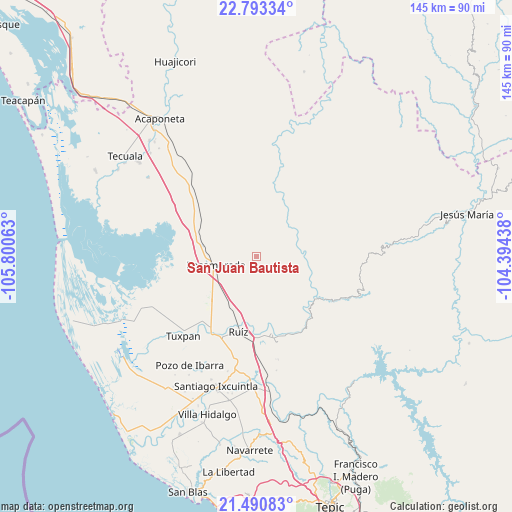
San Juan Bautista GPS coordinates[2]
22° 8' 36.924" North, 105° 5' 51" West
| Map corner | latitude | longitude |
|---|---|---|
| Upper-left | 22.79334°, | -105.80063° |
| Center: | 22.14359°, | -105.0975° |
| Lower-right: | 21.49083°, | -104.39438° |
| Map W x H: | 144.8×144.8 km | = 90×90mi |
| max Lat: | 32.7° ⇑15.1% North |
| San Juan Bautista: | 22.14359° |
| min Lat: | ⇓84.9% South 14.53588° |
| min Long | San Juan Bautis | max Long |
| -117.105° | -105.0975° | -86.73105° |
| W 8%⇐ | ⇒92% E |
Elevation
Elevation of San Juan Bautista is 89 m = 292 ft, and this is 1164.7 m = 3821 ft below average elevation for this country.
| Max E: |
3497 m = 11473 ft | 80.4% |
| Avg. | 1253.7 m = 4113 ft | |
| San Juan Bautista | 89 m = 292 ft | |
Min E: |
-1 m = -3 ft | 19.6% |
See also: Mexico elevation on elevation.city.
Geographical zone
San Juan Bautista is located in North Torrid zone (between Equator and Tropic of Cancer). Distance of this Northern Tropic circle is 143.8 km =89.4 mi to North.| Distance of | km | miles | from San Juan Bautista |
|---|---|---|---|
| North Pole | 7544.9 | 4688.2 | to North |
| Arctic Circle | 4939 | 3069 | to North |
| Tropic Cancer | 143.8 | 89.4 | to North |
| Equator | 2462.1 | 1529.9 | to South |


Nearby cities:
15 places around San Juan Bautista: (largest is in red/bold)
• Chilapa
18.5 km =11.5 mi,  227°
227°
• Cofradía de Cuyutlán
10.1 km =6.3 mi,  190°
190°
• El Vado de San Pedro
23.4 km =14.5 mi,  201°
201°
• Las Pilas
13.9 km =8.6 mi,  209°
209°
• Llano del Tigre
21.5 km =13.4 mi,  265°
265°
• Mojocuautla (Adjuntas)
8.9 km =5.5 mi,  138°
138°
• Paramita
9.8 km =6.1 mi, 267°
• Paso Real del Bejuco
16.6 km =10.3 mi, 213°
• Presidio de los Reyes
21.1 km =13.1 mi,  123°
123°
• Rosamorada
11.5 km =7.1 mi,  257°
257°
• Ruíz
21.9 km =13.6 mi, 192°
• San Lorenzo
22.6 km =14 mi,  175°
175°
• San Pedro Ixcatan
20.4 km =12.7 mi, 124°
• Santa Fe
12.3 km =7.6 mi,  168°
168°
• Teponahuaxtla
13.1 km =8.1 mi,  313°
313°
Sources, notices
• [Note1] Compared only with cities in Mexico existing in our database
• [Src1] Map data: © OpenStreetMap contributors (CC-BY-SA)
• [Src2] Other city data from geonames.org with taken over terms of usage.
• [Src3] Geographical zone / Annual Mean Temperature by Robert A. Rohde @ Wikipedia
