Rosamorada geodata
Rosamorada (Nayarit) is a seat of a second-order administrative division; located in Mexico in America/Mazatlan (GMT-7) time zone. With population of 3,620 people, there are 2533 cities with bigger population in this country. Compared to other cities in Mexico, 84.8% of cities are located further ↓South; 92.4% of cities are located further →East and 90.4% of cities have higher elevation than Rosamorada. Note1


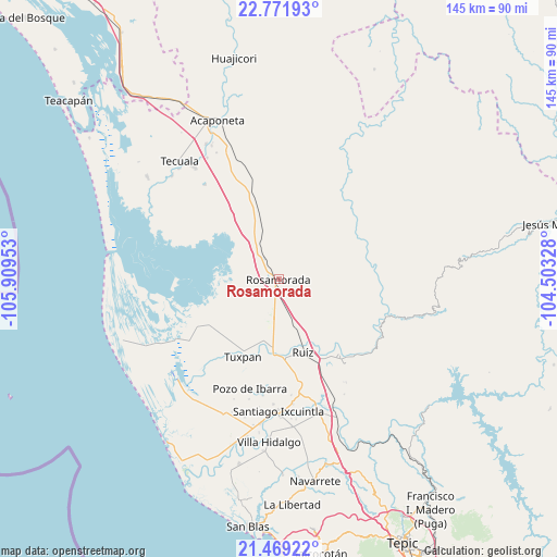
Rosamorada GPS coordinates[2]
22° 7' 19.488" North, 105° 12' 23.04" West
| Map corner | latitude | longitude |
|---|---|---|
| Upper-left | 22.77193°, | -105.90953° |
| Center: | 22.12208°, | -105.2064° |
| Lower-right: | 21.46922°, | -104.50328° |
| Map W x H: | 144.8×144.8 km | = 90×90mi |
| max Lat: | 32.7° ⇑15.2% North |
| Rosamorada: | 22.12208° |
| min Lat: | ⇓84.8% South 14.53588° |
| min Long | Rosamorada | max Long |
| -117.105° | -105.2064° | -86.73105° |
| W 7.6%⇐ | ⇒92.4% E |
Elevation
Elevation of Rosamorada is 23 m = 75 ft, and this is 1230.7 m = 4038 ft below average elevation for this country.
| Max E: |
3497 m = 11473 ft | 90.4% |
| Avg. | 1253.7 m = 4113 ft | |
| Rosamorada | 23 m = 75 ft | |
Min E: |
-1 m = -3 ft | 9.6% |
See also: Mexico elevation on elevation.city.
Geographical zone
Rosamorada is located in North Torrid zone (between Equator and Tropic of Cancer). Distance of this Northern Tropic circle is 146.2 km =90.8 mi to North.| Distance of | km | miles | from Rosamorada |
|---|---|---|---|
| North Pole | 7547.3 | 4689.7 | to North |
| Arctic Circle | 4941.4 | 3070.4 | to North |
| Tropic Cancer | 146.2 | 90.8 | to North |
| Equator | 2459.7 | 1528.4 | to South |


Nearby cities:
15 places around Rosamorada: (largest is in red/bold)
• Chilapa
10.4 km =6.5 mi,  193°
193°
• Cofradía de Cuyutlán
12 km =7.5 mi,  128°
128°
• El Tamarindo
18.4 km =11.4 mi, 188°
• Francisco Villa (El Retiro)
16.7 km =10.4 mi,  310°
310°
• La Boquita
19.5 km =12.1 mi,  225°
225°
• Las Pilas
10.7 km =6.6 mi,  155°
155°
• Llano del Tigre
10.3 km =6.4 mi,  273°
273°
• Mojocuautla (Adjuntas)
17.6 km =10.9 mi,  104°
104°
• Paramita
2.4 km =1.5 mi,  36°
36°
• Paso Real del Bejuco
11.5 km =7.1 mi,  170°
170°
• Pericos
17.2 km =10.7 mi,  241°
241°
• Pescadero
14.3 km =8.9 mi,  300°
300°
• San Juan Bautista
11.5 km =7.1 mi,  77°
77°
• Santa Fe
16.7 km =10.4 mi, 125°
• Teponahuaxtla
11.4 km =7.1 mi,  8°
8°
Sources, notices
• [Note1] Compared only with cities in Mexico existing in our database
• [Src1] Map data: © OpenStreetMap contributors (CC-BY-SA)
• [Src2] Other city data from geonames.org with taken over terms of usage.
• [Src3] Geographical zone / Annual Mean Temperature by Robert A. Rohde @ Wikipedia
