Llano del Tigre geodata
Llano del Tigre (Nayarit) is a populated place; located in Mexico in America/Mazatlan (GMT-7) time zone. With population of 1,038 people, there are 8404 cities with bigger population in this country. Compared to other cities in Mexico, 84.9% of cities are located further ↓South; 92.7% of cities are located further →East and 98.1% of cities have higher elevation than Llano del Tigre. Note1


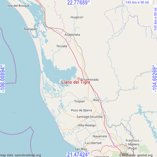
Llano del Tigre GPS coordinates[2]
22° 7' 37.452" North, 105° 18' 20.916" West
| Map corner | latitude | longitude |
|---|---|---|
| Upper-left | 22.77689°, | -106.00894° |
| Center: | 22.12707°, | -105.30581° |
| Lower-right: | 21.47424°, | -104.60269° |
| Map W x H: | 144.8×144.8 km | = 90×90mi |
| max Lat: | 32.7° ⇑15.1% North |
| Llano del Tigre: | 22.12707° |
| min Lat: | ⇓84.9% South 14.53588° |
| min Long | Llano del Tigre | max Long |
| -117.105° | -105.30581° | -86.73105° |
| W 7.3%⇐ | ⇒92.7% E |
Elevation
Elevation of Llano del Tigre is 8 m = 26 ft, and this is 1245.7 m = 4087 ft below average elevation for this country.
| Max E: |
3497 m = 11473 ft | 98.1% |
| Avg. | 1253.7 m = 4113 ft | |
| Llano del Tigre | 8 m = 26 ft | |
Min E: |
-1 m = -3 ft | 1.9% |
See also: Mexico elevation on elevation.city.
Geographical zone
Llano del Tigre is located in North Torrid zone (between Equator and Tropic of Cancer). Distance of this Northern Tropic circle is 145.6 km =90.5 mi to North.| Distance of | km | miles | from Llano del Tigre |
|---|---|---|---|
| North Pole | 7546.8 | 4689.4 | to North |
| Arctic Circle | 4940.9 | 3070.1 | to North |
| Tropic Cancer | 145.6 | 90.5 | to North |
| Equator | 2460.3 | 1528.8 | to South |


Nearby cities:
15 places around Llano del Tigre: (largest is in red/bold)
• Chilapa
13.2 km =8.2 mi,  143°
143°
• El Tamarindo
20.3 km =12.6 mi,  158°
158°
• Francisco Villa (El Retiro)
10.7 km =6.6 mi,  346°
346°
• La Boquita
14.7 km =9.1 mi,  194°
194°
• Las Pilas
18 km =11.2 mi,  125°
125°
• Los Medina
14.7 km =9.1 mi,  200°
200°
• Palma Grande
17.2 km =10.7 mi,  210°
210°
• Paramita
11.8 km =7.3 mi,  83°
83°
• Paso Real del Bejuco
17.1 km =10.6 mi, 134°
• Pericos
10 km =6.2 mi, 209°
• Pescadero
7.1 km =4.4 mi,  342°
342°
• Rosamorada
10.3 km =6.4 mi,  93°
93°
• San Vicente
19.7 km =12.2 mi,  177°
177°
• Teponahuaxtla
16.1 km =10 mi,  47°
47°
• Vicente Guerrero (El Mogote)
15.8 km =9.8 mi, 208°
Sources, notices
• [Note1] Compared only with cities in Mexico existing in our database
• [Src1] Map data: © OpenStreetMap contributors (CC-BY-SA)
• [Src2] Other city data from geonames.org with taken over terms of usage.
• [Src3] Geographical zone / Annual Mean Temperature by Robert A. Rohde @ Wikipedia
