San Felipe geodata
San Felipe (Guanajuato) is a seat of a second-order administrative division; located in Mexico in America/Mexico_City (GMT-6) time zone. With population of 28,452 people, there are 350 cities with bigger population in this country. Compared to other cities in Mexico, 81.3% of cities are located further ↓South; 75.1% of cities are located further →East and 78% of cities have lower elevation than San Felipe. Note1


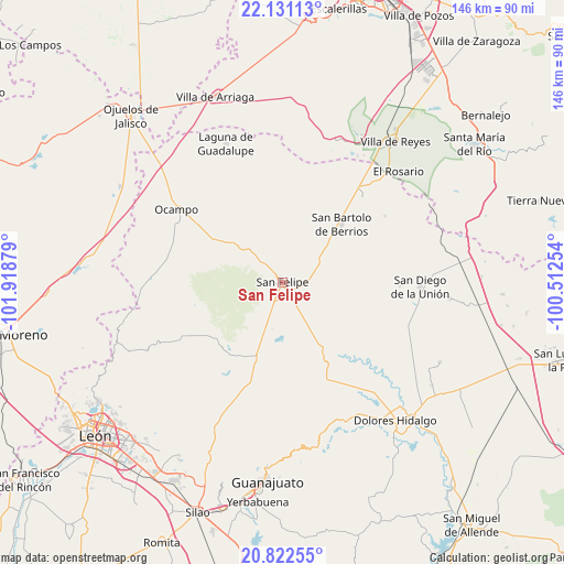
San Felipe GPS coordinates[2]
21° 28' 41.916" North, 101° 12' 56.376" West
| Map corner | latitude | longitude |
|---|---|---|
| Upper-left | 22.13113°, | -101.91879° |
| Center: | 21.47831°, | -101.21566° |
| Lower-right: | 20.82255°, | -100.51254° |
| Map W x H: | 145.5×145.5 km | = 90.4×90.4mi |
| max Lat: | 32.7° ⇑18.7% North |
| San Felipe: | 21.47831° |
| min Lat: | ⇓81.3% South 14.53588° |
| min Long | San Felipe | max Long |
| -117.105° | -101.21566° | -86.73105° |
| W 24.9%⇐ | ⇒75.1% E |
Elevation
Elevation of San Felipe is 2089 m = 6854 ft, and this is 835.3 m = 2740 ft above average elevation for this country.
| Max E: |
3497 m = 11473 ft | 22% |
| San Felipe | 2089 m 6854 ft | |
| Avg. | 1253.7 m = 4113 ft | |
Min E: |
-1 m = -3 ft | 78% |
See also: Mexico elevation on elevation.city.
Geographical zone
San Felipe is located in North Torrid zone (between Equator and Tropic of Cancer). Distance of this Northern Tropic circle is 217.8 km =135.3 mi to North.| Distance of | km | miles | from San Felipe |
|---|---|---|---|
| North Pole | 7618.9 | 4734.2 | to North |
| Arctic Circle | 5013 | 3114.9 | to North |
| Tropic Cancer | 217.8 | 135.3 | to North |
| Equator | 2388.2 | 1484 | to South |


Nearby cities:
15 places around San Felipe: (largest is in red/bold)
• Chirimoya Vieja
15 km =9.3 mi,  54°
54°
• Ejido Hernández Álvarez
2.6 km =1.6 mi,  355°
355°
• El Aposento
9.4 km =5.8 mi,  152°
152°
• El Huizache
13.5 km =8.4 mi,  28°
28°
• Fuerte Viejo
16.6 km =10.3 mi,  308°
308°
• La Estancia del Cubo
14.8 km =9.2 mi,  132°
132°
• La Huerta
6.5 km =4 mi,  157°
157°
• La Sauceda de la Luz
15.2 km =9.4 mi,  9°
9°
• Los Díaz
3.3 km =2.1 mi,  90°
90°
• Molino de San José
11.4 km =7.1 mi,  334°
334°
• Puerto de Sandoval
11.8 km =7.3 mi,  66°
66°
• San Andrés del Cubo
10 km =6.2 mi,  110°
110°
• Santa Bárbara
18 km =11.2 mi,  291°
291°
• Santa Catarina
16.7 km =10.4 mi, 65°
• Santa Rosa
15.2 km =9.4 mi,  57°
57°
Sources, notices
• [Note1] Compared only with cities in Mexico existing in our database
• [Src1] Map data: © OpenStreetMap contributors (CC-BY-SA)
• [Src2] Other city data from geonames.org with taken over terms of usage.
• [Src3] Geographical zone / Annual Mean Temperature by Robert A. Rohde @ Wikipedia
