La Huerta geodata
La Huerta (Guanajuato) is a populated place; located in Mexico in America/Mexico_City (GMT-6) time zone. With population of 783 people, there are 11148 cities with bigger population in this country. Compared to other cities in Mexico, 81% of cities are located further ↓South; 74.9% of cities are located further →East and 76.6% of cities have lower elevation than La Huerta. Note1


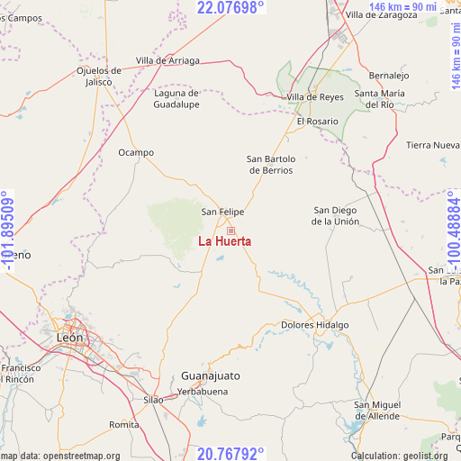
La Huerta GPS coordinates[2]
21° 25' 26.112" North, 101° 11' 31.056" West
| Map corner | latitude | longitude |
|---|---|---|
| Upper-left | 22.07698°, | -101.89509° |
| Center: | 21.42392°, | -101.19196° |
| Lower-right: | 20.76792°, | -100.48884° |
| Map W x H: | 145.6×145.6 km | = 90.5×90.5mi |
| max Lat: | 32.7° ⇑19% North |
| La Huerta: | 21.42392° |
| min Lat: | ⇓81% South 14.53588° |
| min Long | La Huerta | max Long |
| -117.105° | -101.19196° | -86.73105° |
| W 25.1%⇐ | ⇒74.9% E |
Elevation
Elevation of La Huerta is 2059 m = 6755 ft, and this is 805.3 m = 2642 ft above average elevation for this country.
| Max E: |
3497 m = 11473 ft | 23.4% |
| La Huerta | 2059 m 6755 ft | |
| Avg. | 1253.7 m = 4113 ft | |
Min E: |
-1 m = -3 ft | 76.6% |
See also: Mexico elevation on elevation.city.
Geographical zone
La Huerta is located in North Torrid zone (between Equator and Tropic of Cancer). Distance of this Northern Tropic circle is 223.8 km =139.1 mi to North.| Distance of | km | miles | from La Huerta |
|---|---|---|---|
| North Pole | 7624.9 | 4737.9 | to North |
| Arctic Circle | 5019.1 | 3118.7 | to North |
| Tropic Cancer | 223.8 | 139.1 | to North |
| Equator | 2382.1 | 1480.2 | to South |


Nearby cities:
15 places around La Huerta: (largest is in red/bold)
• Cantera Sur
17.3 km =10.7 mi,  210°
210°
• Chirimoya Vieja
17.7 km =11 mi,  33°
33°
• Ejido Hernández Álvarez
9 km =5.6 mi,  343°
343°
• El Aposento
3 km =1.9 mi,  139°
139°
• La Estancia del Cubo
9.3 km =5.8 mi,  114°
114°
• La Labor
17.8 km =11.1 mi, 135°
• La Quemada
14.5 km =9 mi, 142°
• Los Díaz
6.1 km =3.8 mi,  7°
7°
• Molino de San José
18 km =11.2 mi, 335°
• Puerto de Sandoval
13.6 km =8.5 mi,  37°
37°
• San Andrés del Cubo
7.3 km =4.5 mi,  69°
69°
• San Felipe
6.5 km =4 mi, 337°
• San José de los Barcos
14.1 km =8.8 mi,  204°
204°
• Santa Catarina
18.2 km =11.3 mi, 44°
• Santa Rosa
17.6 km =10.9 mi, 36°
Sources, notices
• [Note1] Compared only with cities in Mexico existing in our database
• [Src1] Map data: © OpenStreetMap contributors (CC-BY-SA)
• [Src2] Other city data from geonames.org with taken over terms of usage.
• [Src3] Geographical zone / Annual Mean Temperature by Robert A. Rohde @ Wikipedia
