La Estancia del Cubo geodata
La Estancia del Cubo (Guanajuato) is a populated place; located in Mexico in America/Mexico_City (GMT-6) time zone. With population of 942 people, there are 9249 cities with bigger population in this country. Compared to other cities in Mexico, 80.8% of cities are located further ↓South; 74.3% of cities are located further →East and 76.1% of cities have lower elevation than La Estancia del Cubo. Note1


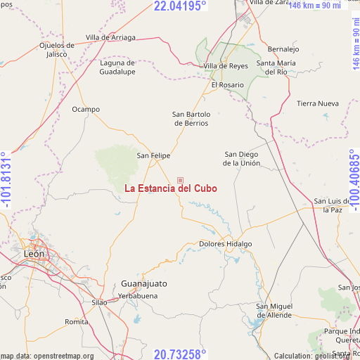
La Estancia del Cubo GPS coordinates[2]
21° 23' 19.428" North, 101° 6' 35.892" West
| Map corner | latitude | longitude |
|---|---|---|
| Upper-left | 22.04195°, | -101.8131° |
| Center: | 21.38873°, | -101.10997° |
| Lower-right: | 20.73258°, | -100.40685° |
| Map W x H: | 145.6×145.6 km | = 90.5×90.5mi |
| max Lat: | 32.7° ⇑19.2% North |
| La Estancia del Cubo: | 21.38873° |
| min Lat: | ⇓80.8% South 14.53588° |
| min Long | La Estancia del | max Long |
| -117.105° | -101.10997° | -86.73105° |
| W 25.7%⇐ | ⇒74.3% E |
Elevation
Elevation of La Estancia del Cubo is 2050 m = 6726 ft, and this is 796.3 m = 2613 ft above average elevation for this country.
| Max E: |
3497 m = 11473 ft | 23.9% |
| La Estancia del Cubo | 2050 m 6726 ft | |
| Avg. | 1253.7 m = 4113 ft | |
Min E: |
-1 m = -3 ft | 76.1% |
See also: Mexico elevation on elevation.city.
Geographical zone
La Estancia del Cubo is located in North Torrid zone (between Equator and Tropic of Cancer). Distance of this Northern Tropic circle is 227.7 km =141.5 mi to North.| Distance of | km | miles | from La Estancia del Cubo |
|---|---|---|---|
| North Pole | 7628.9 | 4740.4 | to North |
| Arctic Circle | 5023 | 3121.1 | to North |
| Tropic Cancer | 227.7 | 141.5 | to North |
| Equator | 2378.2 | 1477.7 | to South |


Nearby cities:
15 places around La Estancia del Cubo: (largest is in red/bold)
• Cantera Sur
20.5 km =12.7 mi,  237°
237°
• Chirimoya Vieja
18.7 km =11.6 mi,  3°
3°
• Ejido Hernández Álvarez
16.8 km =10.4 mi,  318°
318°
• El Aposento
6.7 km =4.2 mi,  283°
283°
• La Huerta
9.3 km =5.8 mi,  294°
294°
• La Labor
9.7 km =6 mi,  155°
155°
• La Quemada
7.6 km =4.7 mi,  177°
177°
• Las Yerbas
20.8 km =12.9 mi,  108°
108°
• Los Díaz
12.6 km =7.8 mi, 322°
• Puerto de Sandoval
14.7 km =9.1 mi,  359°
359°
• San Andrés del Cubo
6.7 km =4.2 mi,  346°
346°
• San Felipe
14.8 km =9.2 mi,  312°
312°
• San José de los Barcos
16.9 km =10.5 mi, 238°
• Santa Catarina
17.5 km =10.9 mi,  14°
14°
• Santa Rosa
18.2 km =11.3 mi, 5°
In other languages:
- In Spanish: La Estancia del Cubo, Estancia de el Cubo, Estancia de la Ordeña, El Salto
Sources, notices
• [Note1] Compared only with cities in Mexico existing in our database
• [Src1] Map data: © OpenStreetMap contributors (CC-BY-SA)
• [Src2] Other city data from geonames.org with taken over terms of usage.
• [Src3] Geographical zone / Annual Mean Temperature by Robert A. Rohde @ Wikipedia
