San Diego de Alcalá geodata
San Diego de Alcalá (Guanajuato) is a populated place; located in Mexico in America/Mexico_City (GMT-6) time zone. With population of 1,140 people, there are 7619 cities with bigger population in this country. Compared to other cities in Mexico, 57.6% of cities are located further ↓South; 72.3% of cities are located further →East and 74.1% of cities have lower elevation than San Diego de Alcalá. Note1


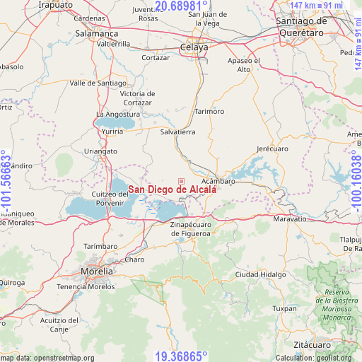
San Diego de Alcalá GPS coordinates[2]
20° 1' 50.232" North, 100° 51' 48.6" West
| Map corner | latitude | longitude |
|---|---|---|
| Upper-left | 20.68981°, | -101.56663° |
| Center: | 20.03062°, | -100.8635° |
| Lower-right: | 19.36865°, | -100.16038° |
| Map W x H: | 146.9×146.9 km | = 91.3×91.3mi |
| max Lat: | 32.7° ⇑42.4% North |
| San Diego de Alcalá: | 20.03062° |
| min Lat: | ⇓57.6% South 14.53588° |
| min Long | San Diego de Al | max Long |
| -117.105° | -100.8635° | -86.73105° |
| W 27.7%⇐ | ⇒72.3% E |
Elevation
Elevation of San Diego de Alcalá is 2015 m = 6611 ft, and this is 761.3 m = 2498 ft above average elevation for this country.
| Max E: |
3497 m = 11473 ft | 25.9% |
| San Diego de Alcalá | 2015 m 6611 ft | |
| Avg. | 1253.7 m = 4113 ft | |
Min E: |
-1 m = -3 ft | 74.1% |
See also: Mexico elevation on elevation.city.
Geographical zone
San Diego de Alcalá is located in North Torrid zone (between Equator and Tropic of Cancer). Distance of this Northern Tropic circle is 378.7 km =235.3 mi to North.| Distance of | km | miles | from San Diego de Alcalá |
|---|---|---|---|
| North Pole | 7779.9 | 4834.2 | to North |
| Arctic Circle | 5174 | 3215 | to North |
| Tropic Cancer | 378.7 | 235.3 | to North |
| Equator | 2227.2 | 1383.9 | to South |


Nearby cities:
15 places around San Diego de Alcalá: (largest is in red/bold)
• Andocutín
8.3 km =5.2 mi,  181°
181°
• Araró
13.9 km =8.6 mi,  162°
162°
• Chamácuaro
9 km =5.6 mi,  24°
24°
• Estancia del Carmen de Maravatío
10.5 km =6.5 mi,  326°
326°
• Irámuco
9.8 km =6.1 mi,  218°
218°
• La Merced
5.5 km =3.4 mi,  91°
91°
• La Palma de Eménguaro
12.9 km =8 mi,  344°
344°
• La Virgen
13.1 km =8.1 mi, 340°
• Las Jícamas
4.2 km =2.6 mi,  30°
30°
• Monte Prieto
10.4 km =6.5 mi,  54°
54°
• Obrajuelo
8.7 km =5.4 mi,  9°
9°
• San Antonio Eménguaro
12.3 km =7.6 mi,  352°
352°
• San Juan Jaripeo
11.1 km =6.9 mi,  104°
104°
• San Juan Viejo
13.9 km =8.6 mi,  59°
59°
• San Pablo Pejo
7.8 km =4.8 mi,  272°
272°
Sources, notices
• [Note1] Compared only with cities in Mexico existing in our database
• [Src1] Map data: © OpenStreetMap contributors (CC-BY-SA)
• [Src2] Other city data from geonames.org with taken over terms of usage.
• [Src3] Geographical zone / Annual Mean Temperature by Robert A. Rohde @ Wikipedia
