Coina Grande geodata
Coina Grande (Jalisco) is a populated place; located in Mexico in America/Mexico_City (GMT-6) time zone. With population of 562 people, there are 15183 cities with bigger population in this country. Compared to other cities in Mexico, 68.3% of cities are located further ↓South; 85% of cities are located further →East and 53.1% of cities have lower elevation than Coina Grande. Note1


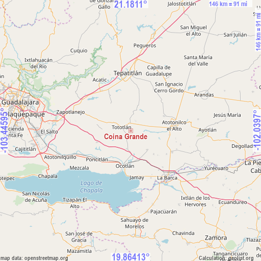
Coina Grande GPS coordinates[2]
20° 31' 26.508" North, 102° 44' 34.152" West
| Map corner | latitude | longitude |
|---|---|---|
| Upper-left | 21.1811°, | -103.44595° |
| Center: | 20.52403°, | -102.74282° |
| Lower-right: | 19.86413°, | -102.0397° |
| Map W x H: | 146.4×146.4 km | = 91×91mi |
| max Lat: | 32.7° ⇑31.7% North |
| Coina Grande: | 20.52403° |
| min Lat: | ⇓68.3% South 14.53588° |
| min Long | Coina Grande | max Long |
| -117.105° | -102.74282° | -86.73105° |
| W 15%⇐ | ⇒85% E |
Elevation
Elevation of Coina Grande is 1543 m = 5062 ft, and this is 289.3 m = 949 ft above average elevation for this country.
| Max E: |
3497 m = 11473 ft | 46.9% |
| Coina Grande | 1543 m 5062 ft | |
| Avg. | 1253.7 m = 4113 ft | |
Min E: |
-1 m = -3 ft | 53.1% |
See also: Mexico elevation on elevation.city.
Geographical zone
Coina Grande is located in North Torrid zone (between Equator and Tropic of Cancer). Distance of this Northern Tropic circle is 323.9 km =201.3 mi to North.| Distance of | km | miles | from Coina Grande |
|---|---|---|---|
| North Pole | 7725 | 4800.1 | to North |
| Arctic Circle | 5119.1 | 3180.9 | to North |
| Tropic Cancer | 323.9 | 201.3 | to North |
| Equator | 2282.1 | 1418 | to South |


Nearby cities:
15 places around Coina Grande: (largest is in red/bold)
• Carrozas
4.4 km =2.7 mi,  166°
166°
• El Sauz
7.9 km =4.9 mi,  230°
230°
• Joconoxtle (La Tuna)
10.6 km =6.6 mi,  139°
139°
• La Noria
13.2 km =8.2 mi, 234°
• Los Cerritos
6.2 km =3.9 mi,  213°
213°
• Nuevo Refugio de Afuera (Nuevo Refugio)
4.6 km =2.9 mi,  53°
53°
• Otatlán
11.2 km =7 mi, 214°
• Ramblas Chico
12.8 km =8 mi,  326°
326°
• Rancho Viejo del Refugio
13.5 km =8.4 mi,  126°
126°
• San Agustín
12.5 km =7.8 mi,  13°
13°
• San Antonio de Fernández
13.4 km =8.3 mi,  76°
76°
• San Isidro
6.1 km =3.8 mi,  26°
26°
• San Martín de Zula
12.8 km =8 mi, 173°
• Santa Clara de Zula
13.1 km =8.1 mi, 167°
• Tototlán
5.5 km =3.4 mi,  291°
291°
Sources, notices
• [Note1] Compared only with cities in Mexico existing in our database
• [Src1] Map data: © OpenStreetMap contributors (CC-BY-SA)
• [Src2] Other city data from geonames.org with taken over terms of usage.
• [Src3] Geographical zone / Annual Mean Temperature by Robert A. Rohde @ Wikipedia
