Joconoxtle (La Tuna) geodata
Joconoxtle (La Tuna) (Jalisco) is a populated place; located in Mexico in America/Mexico_City (GMT-6) time zone. With population of 1,059 people, there are 8240 cities with bigger population in this country. Compared to other cities in Mexico, 66.7% of cities are located further ↓South; 84.7% of cities are located further →East and 53.6% of cities have lower elevation than Joconoxtle (La Tuna). Note1
Current local time in Joconoxtle (La Tuna):
05:32 AM, WednesdayDifference from your time zone: hours


Joconoxtle (La Tuna) GPS coordinates[2]
20° 27' 7.992" North, 102° 40' 35.004" West
| Map corner | latitude | longitude |
|---|---|---|
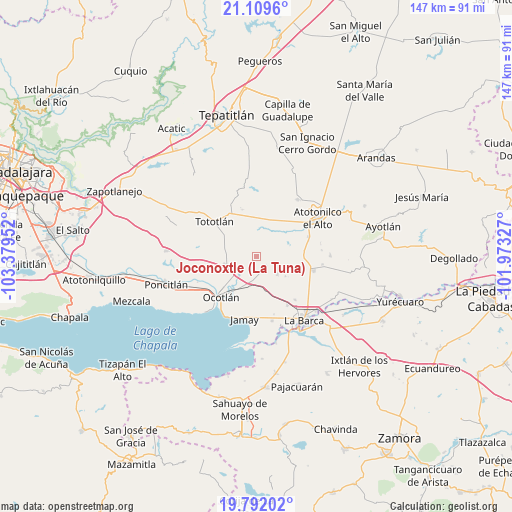
| Upper-left | 21.1096°, | -103.37952° |
| Center: | 20.45222°, | -102.67639° |
| Lower-right: | 19.79202°, | -101.97327° |
| Map W x H: | 146.5×146.5 km | = 91×91mi |
| max Lat: | 32.7° ⇑33.3% North |
| Joconoxtle (La Tuna): | 20.45222° |
| min Lat: | ⇓66.7% South 14.53588° |
| min Long | Joconoxtle (La | max Long |
| -117.105° | -102.67639° | -86.73105° |
| W 15.3%⇐ | ⇒84.7% E |
Elevation
Elevation of Joconoxtle (La Tuna) is 1554 m = 5098 ft, and this is 300.3 m = 985 ft above average elevation for this country.
| Max E: |
3497 m = 11473 ft | 46.4% |
| Joconoxtle (La Tuna) | 1554 m 5098 ft | |
| Avg. | 1253.7 m = 4113 ft | |
Min E: |
-1 m = -3 ft | 53.6% |
See also: Mexico elevation on elevation.city.
Geographical zone
Joconoxtle (La Tuna) is located in North Torrid zone (between Equator and Tropic of Cancer). Distance of this Northern Tropic circle is 331.8 km =206.2 mi to North.| Distance of | km | miles | from Joconoxtle (La Tuna) |
|---|---|---|---|
| North Pole | 7733 | 4805.1 | to North |
| Arctic Circle | 5127.1 | 3185.8 | to North |
| Tropic Cancer | 331.8 | 206.2 | to North |
| Equator | 2274.1 | 1413.1 | to South |


Nearby cities:
15 places around Joconoxtle (La Tuna): (largest is in red/bold)
• Canales
8 km =5 mi,  130°
130°
• Carrozas
7 km =4.3 mi,  301°
301°
• Coina Grande
10.6 km =6.6 mi,  319°
319°
• Cucarachas
12.7 km =7.9 mi,  75°
75°
• Guayabos
10.1 km =6.3 mi,  124°
124°
• Los Cerritos
10.7 km =6.6 mi,  285°
285°
• Nuevo Refugio de Afuera (Nuevo Refugio)
11.2 km =7 mi,  343°
343°
• Nuevo Valle (Ex-Hacienda del Valle)
9.5 km =5.9 mi, 77°
• Rancho Viejo del Refugio
3.9 km =2.4 mi,  92°
92°
• San Antonio de Fernández
12.7 km =7.9 mi,  28°
28°
• San José del Valle
9 km =5.6 mi, 78°
• San Martín de Zula
7.2 km =4.5 mi,  228°
228°
• San Miguel de la Paz
9.2 km =5.7 mi,  171°
171°
• San Vicente
3.5 km =2.2 mi,  139°
139°
• Santa Clara de Zula
6.4 km =4 mi,  220°
220°
Sources, notices
• [Note1] Compared only with cities in Mexico existing in our database
• [Src1] Map data: © OpenStreetMap contributors (CC-BY-SA)
• [Src2] Other city data from geonames.org with taken over terms of usage.
• [Src3] Geographical zone / Annual Mean Temperature by Robert A. Rohde @ Wikipedia
