San Ángel geodata
San Ángel (Guanajuato) is a populated place; located in Mexico in America/Mexico_City (GMT-6) time zone. With population of 1,563 people, there are 5525 cities with bigger population in this country. Compared to other cities in Mexico, 74.9% of cities are located further ↓South; 80.5% of cities are located further →East and 61.8% of cities have lower elevation than San Ángel. Note1


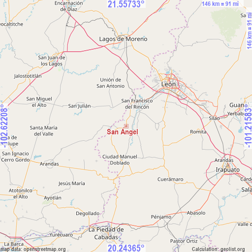
San Ángel GPS coordinates[2]
20° 54' 6.948" North, 101° 55' 8.22" West
| Map corner | latitude | longitude |
|---|---|---|
| Upper-left | 21.55733°, | -102.62208° |
| Center: | 20.90193°, | -101.91895° |
| Lower-right: | 20.24365°, | -101.21583° |
| Map W x H: | 146.1×146.1 km | = 90.8×90.8mi |
| max Lat: | 32.7° ⇑25.1% North |
| San Ángel: | 20.90193° |
| min Lat: | ⇓74.9% South 14.53588° |
| min Long | San Ángel | max Long |
| -117.105° | -101.91895° | -86.73105° |
| W 19.5%⇐ | ⇒80.5% E |
Elevation
Elevation of San Ángel is 1755 m = 5758 ft, and this is 501.3 m = 1645 ft above average elevation for this country.
| Max E: |
3497 m = 11473 ft | 38.2% |
| San Ángel | 1755 m 5758 ft | |
| Avg. | 1253.7 m = 4113 ft | |
Min E: |
-1 m = -3 ft | 61.8% |
See also: Mexico elevation on elevation.city.
Geographical zone
San Ángel is located in North Torrid zone (between Equator and Tropic of Cancer). Distance of this Northern Tropic circle is 281.8 km =175.1 mi to North.| Distance of | km | miles | from San Ángel |
|---|---|---|---|
| North Pole | 7683 | 4774 | to North |
| Arctic Circle | 5077.1 | 3154.8 | to North |
| Tropic Cancer | 281.8 | 175.1 | to North |
| Equator | 2324.1 | 1444.1 | to South |


Nearby cities:
15 places around San Ángel: (largest is in red/bold)
• Cañada de Negros
2.7 km =1.7 mi,  355°
355°
• Dolores
5.6 km =3.5 mi,  18°
18°
• El Nacimiento
8 km =5 mi,  128°
128°
• El Refugio
7.2 km =4.5 mi, 18°
• El Tecolote
2.1 km =1.3 mi,  195°
195°
• El Tecuán
10.1 km =6.3 mi,  145°
145°
• El Toro
8.2 km =5.1 mi,  171°
171°
• Guadalupe de Jalpa
7.7 km =4.8 mi,  233°
233°
• Jalpa de Cánovas
7.1 km =4.4 mi,  250°
250°
• Peñuelas
7.3 km =4.5 mi,  109°
109°
• San Bernardo
8.9 km =5.5 mi,  34°
34°
• San Ignacio de Hidalgo
6.2 km =3.9 mi,  79°
79°
• San Nicolás del Palenque
9.5 km =5.9 mi,  10°
10°
• San Roque de Torres
10.3 km =6.4 mi,  41°
41°
• Silva
8.1 km =5 mi,  52°
52°
Sources, notices
• [Note1] Compared only with cities in Mexico existing in our database
• [Src1] Map data: © OpenStreetMap contributors (CC-BY-SA)
• [Src2] Other city data from geonames.org with taken over terms of usage.
• [Src3] Geographical zone / Annual Mean Temperature by Robert A. Rohde @ Wikipedia
