Guadalupe de Jalpa geodata
Guadalupe de Jalpa (Guanajuato) is a populated place; located in Mexico in America/Mexico_City (GMT-6) time zone. With population of 879 people, there are 9939 cities with bigger population in this country. Compared to other cities in Mexico, 74.1% of cities are located further ↓South; 80.8% of cities are located further →East and 61.2% of cities have lower elevation than Guadalupe de Jalpa. Note1


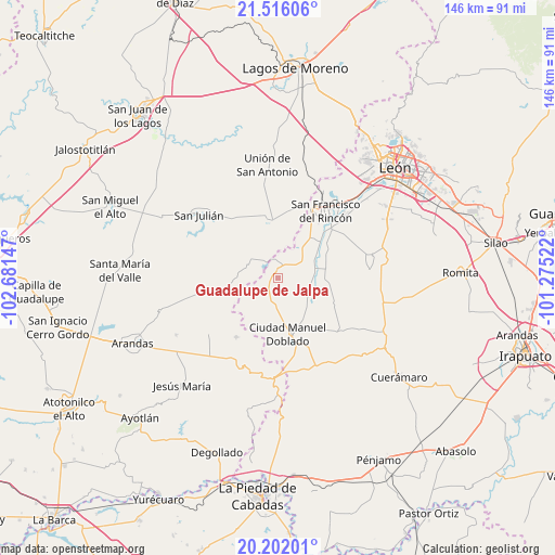
Guadalupe de Jalpa GPS coordinates[2]
20° 51' 37.692" North, 101° 58' 42.024" West
| Map corner | latitude | longitude |
|---|---|---|
| Upper-left | 21.51606°, | -102.68147° |
| Center: | 20.86047°, | -101.97834° |
| Lower-right: | 20.20201°, | -101.27522° |
| Map W x H: | 146.1×146.1 km | = 90.8×90.8mi |
| max Lat: | 32.7° ⇑25.9% North |
| Guadalupe de Jalpa: | 20.86047° |
| min Lat: | ⇓74.1% South 14.53588° |
| min Long | Guadalupe de Ja | max Long |
| -117.105° | -101.97834° | -86.73105° |
| W 19.2%⇐ | ⇒80.8% E |
Elevation
Elevation of Guadalupe de Jalpa is 1747 m = 5732 ft, and this is 493.3 m = 1618 ft above average elevation for this country.
| Max E: |
3497 m = 11473 ft | 38.8% |
| Guadalupe de Jalpa | 1747 m 5732 ft | |
| Avg. | 1253.7 m = 4113 ft | |
Min E: |
-1 m = -3 ft | 61.2% |
See also: Mexico elevation on elevation.city.
Geographical zone
Guadalupe de Jalpa is located in North Torrid zone (between Equator and Tropic of Cancer). Distance of this Northern Tropic circle is 286.5 km =178 mi to North.| Distance of | km | miles | from Guadalupe de Jalpa |
|---|---|---|---|
| North Pole | 7687.6 | 4776.9 | to North |
| Arctic Circle | 5081.7 | 3157.6 | to North |
| Tropic Cancer | 286.5 | 178 | to North |
| Equator | 2319.5 | 1441.3 | to South |


Nearby cities:
15 places around Guadalupe de Jalpa: (largest is in red/bold)
• Cañada de Negros
9.4 km =5.8 mi,  39°
39°
• Ciudad Manuel Doblado
14.9 km =9.3 mi,  169°
169°
• Dolores
12.7 km =7.9 mi, 38°
• El Nacimiento
12.5 km =7.8 mi,  91°
91°
• El Refugio
14.2 km =8.8 mi, 36°
• El Tecolote
6.2 km =3.9 mi,  64°
64°
• El Tecuán
12.4 km =7.7 mi,  107°
107°
• El Toro
8.2 km =5.1 mi,  115°
115°
• Frías
7 km =4.3 mi,  195°
195°
• Jalpa de Cánovas
2.3 km =1.4 mi,  346°
346°
• La Ladera
11.2 km =7 mi,  187°
187°
• Maravillas
14.9 km =9.3 mi,  149°
149°
• Peñuelas
13.2 km =8.2 mi,  80°
80°
• San Ignacio de Hidalgo
13.5 km =8.4 mi,  65°
65°
• San Ángel
7.7 km =4.8 mi,  53°
53°
Sources, notices
• [Note1] Compared only with cities in Mexico existing in our database
• [Src1] Map data: © OpenStreetMap contributors (CC-BY-SA)
• [Src2] Other city data from geonames.org with taken over terms of usage.
• [Src3] Geographical zone / Annual Mean Temperature by Robert A. Rohde @ Wikipedia
