El Tecolote geodata
El Tecolote (Guanajuato) is a populated place; located in Mexico in America/Mexico_City (GMT-6) time zone. With population of 1,411 people, there are 6128 cities with bigger population in this country. Compared to other cities in Mexico, 74.6% of cities are located further ↓South; 80.5% of cities are located further →East and 60.7% of cities have lower elevation than El Tecolote. Note1


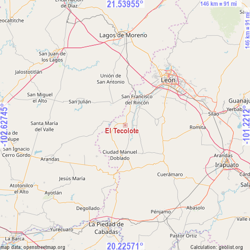
El Tecolote GPS coordinates[2]
20° 53' 2.652" North, 101° 55' 27.552" West
| Map corner | latitude | longitude |
|---|---|---|
| Upper-left | 21.53955°, | -102.62745° |
| Center: | 20.88407°, | -101.92432° |
| Lower-right: | 20.22571°, | -101.2212° |
| Map W x H: | 146.1×146.1 km | = 90.8×90.8mi |
| max Lat: | 32.7° ⇑25.4% North |
| El Tecolote: | 20.88407° |
| min Lat: | ⇓74.6% South 14.53588° |
| min Long | El Tecolote | max Long |
| -117.105° | -101.92432° | -86.73105° |
| W 19.5%⇐ | ⇒80.5% E |
Elevation
Elevation of El Tecolote is 1738 m = 5702 ft, and this is 484.3 m = 1589 ft above average elevation for this country.
| Max E: |
3497 m = 11473 ft | 39.3% |
| El Tecolote | 1738 m 5702 ft | |
| Avg. | 1253.7 m = 4113 ft | |
Min E: |
-1 m = -3 ft | 60.7% |
See also: Mexico elevation on elevation.city.
Geographical zone
El Tecolote is located in North Torrid zone (between Equator and Tropic of Cancer). Distance of this Northern Tropic circle is 283.8 km =176.3 mi to North.| Distance of | km | miles | from El Tecolote |
|---|---|---|---|
| North Pole | 7685 | 4775.2 | to North |
| Arctic Circle | 5079.1 | 3156 | to North |
| Tropic Cancer | 283.8 | 176.3 | to North |
| Equator | 2322.1 | 1442.9 | to South |


Nearby cities:
15 places around El Tecolote: (largest is in red/bold)
• Cañada de Negros
4.7 km =2.9 mi,  4°
4°
• Dolores
7.6 km =4.7 mi,  18°
18°
• El Nacimiento
7.5 km =4.7 mi,  113°
113°
• El Refugio
9.3 km =5.8 mi, 17°
• El Tecuán
8.9 km =5.5 mi,  135°
135°
• El Toro
6.4 km =4 mi,  163°
163°
• Frías
12 km =7.5 mi,  218°
218°
• Guadalupe de Jalpa
6.2 km =3.9 mi,  244°
244°
• Jalpa de Cánovas
6.1 km =3.8 mi,  265°
265°
• Peñuelas
7.4 km =4.6 mi,  93°
93°
• San Bernardo
10.9 km =6.8 mi,  31°
31°
• San Ignacio de Hidalgo
7.3 km =4.5 mi,  65°
65°
• San Nicolás del Palenque
11.5 km =7.1 mi,  11°
11°
• San Ángel
2.1 km =1.3 mi, 15°
• Silva
9.8 km =6.1 mi,  45°
45°
Sources, notices
• [Note1] Compared only with cities in Mexico existing in our database
• [Src1] Map data: © OpenStreetMap contributors (CC-BY-SA)
• [Src2] Other city data from geonames.org with taken over terms of usage.
• [Src3] Geographical zone / Annual Mean Temperature by Robert A. Rohde @ Wikipedia
