Rosales geodata
Rosales (Sonora) is a populated place; located in Mexico in America/Hermosillo (GMT-7) time zone. With population of 1,214 people, there are 7165 cities with bigger population in this country. Compared to other cities in Mexico, 96.5% of cities are located further ↓South; 97.5% of cities are located further →East and 85.1% of cities have higher elevation than Rosales. Note1


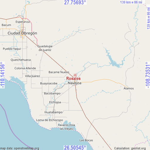
Rosales GPS coordinates[2]
27° 7' 58.584" North, 109° 26' 18.348" West
| Map corner | latitude | longitude |
|---|---|---|
| Upper-left | 27.75693°, | -110.14156° |
| Center: | 27.13294°, | -109.43843° |
| Lower-right: | 26.50545°, | -108.73531° |
| Map W x H: | 139.2×139.2 km | = 86.5×86.5mi |
| max Lat: | 32.7° ⇑3.5% North |
| Rosales: | 27.13294° |
| min Lat: | ⇓96.5% South 14.53588° |
| min Long | Rosales | max Long |
| -117.105° | -109.43843° | -86.73105° |
| W 2.5%⇐ | ⇒97.5% E |
Elevation
Elevation of Rosales is 43 m = 141 ft, and this is 1210.7 m = 3972 ft below average elevation for this country.
| Max E: |
3497 m = 11473 ft | 85.1% |
| Avg. | 1253.7 m = 4113 ft | |
| Rosales | 43 m = 141 ft | |
Min E: |
-1 m = -3 ft | 14.9% |
See also: Mexico elevation on elevation.city.
Geographical zone
Rosales is located in North temperate zone (between Tropic of Cancer and the Arctic Circle). Distance of this Northern Tropic circle is 411 km =255.4 mi to South.| Distance of | km | miles | from Rosales |
|---|---|---|---|
| North Pole | 6990.2 | 4343.5 | to North |
| Arctic Circle | 4384.3 | 2724.3 | to North |
| Tropic Cancer | 411 | 255.4 | to South |
| Equator | 3016.9 | 1874.6 | to South |


Nearby cities:
15 places around Rosales: (largest is in red/bold)
• Aquichopo
13.6 km =8.5 mi,  242°
242°
• Buiyacusi
2 km =1.2 mi,  30°
30°
• Capohuiza
1 km =0.6 mi,  263°
263°
• Chibucú
4.3 km =2.7 mi,  115°
115°
• Chinotahueca
15.2 km =9.4 mi,  217°
217°
• El Recodo
10.8 km =6.7 mi,  234°
234°
• El Siviral (Jigica)
7.1 km =4.4 mi, 241°
• Guaymitas
2.5 km =1.6 mi,  179°
179°
• Loma del Refugio
2.4 km =1.5 mi, 239°
• Los Bahuises
3.4 km =2.1 mi, 237°
• Navojoa
7 km =4.3 mi, 184°
• Pueblo Mayo
14 km =8.7 mi,  304°
304°
• Rancho Camargo
9.8 km =6.1 mi,  248°
248°
• Siviral
7.2 km =4.5 mi, 241°
• Tierra Blanca
11.1 km =6.9 mi,  56°
56°
Sources, notices
• [Note1] Compared only with cities in Mexico existing in our database
• [Src1] Map data: © OpenStreetMap contributors (CC-BY-SA)
• [Src2] Other city data from geonames.org with taken over terms of usage.
• [Src3] Geographical zone / Annual Mean Temperature by Robert A. Rohde @ Wikipedia
