Jesús María geodata
Jesús María (San Luis Potosí) is a populated place; located in Mexico in America/Mexico_City (GMT-6) time zone. With population of 1,979 people, there are 4404 cities with bigger population in this country. Compared to other cities in Mexico, 88.3% of cities are located further ↓South; 82% of cities are located further →East and 71.9% of cities have lower elevation than Jesús María. Note1


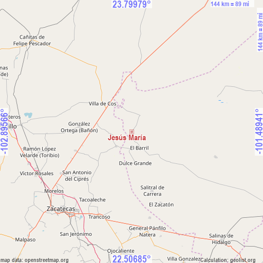
Jesús María GPS coordinates[2]
23° 9' 17.568" North, 102° 11' 33.108" West
| Map corner | latitude | longitude |
|---|---|---|
| Upper-left | 23.79979°, | -102.89566° |
| Center: | 23.15488°, | -102.19253° |
| Lower-right: | 22.50685°, | -101.48941° |
| Map W x H: | 143.8×143.8 km | = 89.4×89.4mi |
| max Lat: | 32.7° ⇑11.7% North |
| Jesús María: | 23.15488° |
| min Lat: | ⇓88.3% South 14.53588° |
| min Long | Jesús María | max Long |
| -117.105° | -102.19253° | -86.73105° |
| W 18%⇐ | ⇒82% E |
Elevation
Elevation of Jesús María is 1965 m = 6447 ft, and this is 711.3 m = 2334 ft above average elevation for this country.
| Max E: |
3497 m = 11473 ft | 28.1% |
| Jesús María | 1965 m 6447 ft | |
| Avg. | 1253.7 m = 4113 ft | |
Min E: |
-1 m = -3 ft | 71.9% |
See also: Mexico elevation on elevation.city.
Geographical zone
Jesús María is located in North Torrid zone (between Equator and Tropic of Cancer). Distance of this Northern Tropic circle is 31.3 km =19.4 mi to North.| Distance of | km | miles | from Jesús María |
|---|---|---|---|
| North Pole | 7432.5 | 4618.3 | to North |
| Arctic Circle | 4826.6 | 2999.1 | to North |
| Tropic Cancer | 31.3 | 19.4 | to North |
| Equator | 2574.6 | 1599.8 | to South |


Nearby cities:
15 places around Jesús María: (largest is in red/bold)
• Chaparrosa
11.8 km =7.3 mi,  227°
227°
• Chupaderos
13.6 km =8.5 mi,  271°
271°
• Dulce Grande
17.1 km =10.6 mi,  173°
173°
• El Barril
9.7 km =6 mi,  155°
155°
• El Rucio
30.3 km =18.8 mi,  21°
21°
• Gonzales Ortega
29.1 km =18.1 mi,  275°
275°
• Hernández
20.8 km =12.9 mi,  130°
130°
• Illescas
10.7 km =6.6 mi,  27°
27°
• La Prieta
24.3 km =15.1 mi,  12°
12°
• Los Zacatones
25.7 km =16 mi,  146°
146°
• Providencia
18.7 km =11.6 mi,  85°
85°
• San Juan
25 km =15.5 mi, 231°
• San Ramón
24.1 km =15 mi, 269°
• Villa de Cos
22.3 km =13.9 mi,  313°
313°
• Zancarron
24.3 km =15.1 mi,  353°
353°
Sources, notices
• [Note1] Compared only with cities in Mexico existing in our database
• [Src1] Map data: © OpenStreetMap contributors (CC-BY-SA)
• [Src2] Other city data from geonames.org with taken over terms of usage.
• [Src3] Geographical zone / Annual Mean Temperature by Robert A. Rohde @ Wikipedia
