Illescas geodata
Illescas (San Luis Potosí) is a populated place; located in Mexico in America/Mexico_City (GMT-6) time zone. With population of 1,727 people, there are 5025 cities with bigger population in this country. Compared to other cities in Mexico, 88.5% of cities are located further ↓South; 81.8% of cities are located further →East and 70.9% of cities have lower elevation than Illescas. Note1


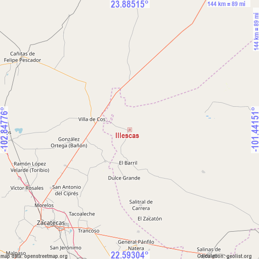
Illescas GPS coordinates[2]
23° 14' 26.376" North, 102° 8' 40.668" West
| Map corner | latitude | longitude |
|---|---|---|
| Upper-left | 23.88515°, | -102.84776° |
| Center: | 23.24066°, | -102.14463° |
| Lower-right: | 22.59304°, | -101.44151° |
| Map W x H: | 143.7×143.7 km | = 89.3×89.3mi |
| max Lat: | 32.7° ⇑11.5% North |
| Illescas: | 23.24066° |
| min Lat: | ⇓88.5% South 14.53588° |
| min Long | Illescas | max Long |
| -117.105° | -102.14463° | -86.73105° |
| W 18.2%⇐ | ⇒81.8% E |
Elevation
Elevation of Illescas is 1942 m = 6371 ft, and this is 688.3 m = 2258 ft above average elevation for this country.
| Max E: |
3497 m = 11473 ft | 29.1% |
| Illescas | 1942 m 6371 ft | |
| Avg. | 1253.7 m = 4113 ft | |
Min E: |
-1 m = -3 ft | 70.9% |
See also: Mexico elevation on elevation.city.
Geographical zone
Illescas is located in North Torrid zone (between Equator and Tropic of Cancer). Distance of this Northern Tropic circle is 21.8 km =13.5 mi to North.| Distance of | km | miles | from Illescas |
|---|---|---|---|
| North Pole | 7422.9 | 4612.4 | to North |
| Arctic Circle | 4817.1 | 2993.2 | to North |
| Tropic Cancer | 21.8 | 13.5 | to North |
| Equator | 2584.1 | 1605.7 | to South |


Nearby cities:
15 places around Illescas: (largest is in red/bold)
• Cañas
25 km =15.5 mi,  330°
330°
• Cervantes
21.5 km =13.4 mi,  38°
38°
• Chaparrosa
22.1 km =13.7 mi,  217°
217°
• Chupaderos
20.6 km =12.8 mi,  243°
243°
• Dulce Grande
26.7 km =16.6 mi,  186°
186°
• El Barril
18.4 km =11.4 mi,  182°
182°
• El Rucio
19.6 km =12.2 mi,  19°
19°
• Hernández
25.5 km =15.8 mi,  154°
154°
• Jesús María
10.7 km =6.6 mi,  207°
207°
• La Prieta
14.1 km =8.8 mi,  1°
1°
• Los Zacatones
32.4 km =20.1 mi,  163°
163°
• Providencia
16 km =9.9 mi,  120°
120°
• San Ramón
30.7 km =19.1 mi,  251°
251°
• Villa de Cos
21.8 km =13.5 mi,  285°
285°
• Zancarron
16.5 km =10.3 mi, 332°
Sources, notices
• [Note1] Compared only with cities in Mexico existing in our database
• [Src1] Map data: © OpenStreetMap contributors (CC-BY-SA)
• [Src2] Other city data from geonames.org with taken over terms of usage.
• [Src3] Geographical zone / Annual Mean Temperature by Robert A. Rohde @ Wikipedia
