Nazas geodata
Nazas (Durango) is a seat of a second-order administrative division; located in Mexico in America/Monterrey (GMT-6) time zone. With population of 3,622 people, there are 2530 cities with bigger population in this country. Compared to other cities in Mexico, 92% of cities are located further ↓South; 90.3% of cities are located further →East and 53.8% of cities have higher elevation than Nazas. Note1


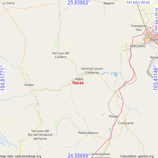
Nazas GPS coordinates[2]
25° 13' 28.632" North, 104° 6' 52.488" West
| Map corner | latitude | longitude |
|---|---|---|
| Upper-left | 25.85902°, | -104.81771° |
| Center: | 25.22462°, | -104.11458° |
| Lower-right: | 24.58689°, | -103.41146° |
| Map W x H: | 141.4×141.4 km | = 87.9×87.9mi |
| max Lat: | 32.7° ⇑8% North |
| Nazas: | 25.22462° |
| min Lat: | ⇓92% South 14.53588° |
| min Long | Nazas | max Long |
| -117.105° | -104.11458° | -86.73105° |
| W 9.7%⇐ | ⇒90.3% E |
Elevation
Elevation of Nazas is 1253 m = 4111 ft, and this is 0.70000000000005 m = 2 ft below average elevation for this country.
| Max E: |
3497 m = 11473 ft | 53.8% |
| Avg. | 1253.7 m = 4113 ft | |
| Nazas | 1253 m = 4111 ft | |
Min E: |
-1 m = -3 ft | 46.2% |
See also: Mexico elevation on elevation.city.
Geographical zone
Nazas is located in North temperate zone (between Tropic of Cancer and the Arctic Circle). Distance of this Northern Tropic circle is 198.8 km =123.5 mi to South.| Distance of | km | miles | from Nazas |
|---|---|---|---|
| North Pole | 7202.3 | 4475.3 | to North |
| Arctic Circle | 4596.5 | 2856.1 | to North |
| Tropic Cancer | 198.8 | 123.5 | to South |
| Equator | 2804.7 | 1742.8 | to South |


Nearby cities:
15 places around Nazas: (largest is in red/bold)
• Emilio Carranza
17.5 km =10.9 mi,  77°
77°
• General Lázaro Cárdenas
14 km =8.7 mi,  56°
56°
• La Perla
9.4 km =5.8 mi,  44°
44°
• Las Mercedes
34 km =21.1 mi,  127°
127°
• Los Cuatillos
37.4 km =23.2 mi,  112°
112°
• Nuevo Graseros
37.5 km =23.3 mi, 84°
• Pasaje
45.2 km =28.1 mi,  136°
136°
• Paso Nacional
10.5 km =6.5 mi,  65°
65°
• Pedriceña
34.8 km =21.6 mi, 109°
• Rodeo
45.1 km =28 mi,  263°
263°
• San Luis del Cordero
26.8 km =16.7 mi,  322°
322°
• San Pedro del Gallo
41.8 km =26 mi,  334°
334°
• Santa Bárbara
46.1 km =28.6 mi,  271°
271°
• Santa Teresa de la Uña
13.9 km =8.6 mi, 72°
• Velardeña
42 km =26.1 mi,  115°
115°
Sources, notices
• [Note1] Compared only with cities in Mexico existing in our database
• [Src1] Map data: © OpenStreetMap contributors (CC-BY-SA)
• [Src2] Other city data from geonames.org with taken over terms of usage.
• [Src3] Geographical zone / Annual Mean Temperature by Robert A. Rohde @ Wikipedia
