Otatillos geodata
Otatillos (Sinaloa) is a populated place; located in Mexico in America/Mazatlan (GMT-7) time zone. With population of 506 people, there are 16626 cities with bigger population in this country. Compared to other cities in Mexico, 92.4% of cities are located further ↓South; 94.7% of cities are located further →East and 74.5% of cities have higher elevation than Otatillos. Note1


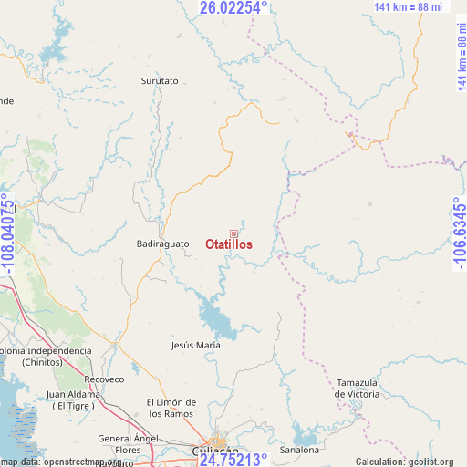
Otatillos GPS coordinates[2]
25° 23' 20.436" North, 107° 20' 15.432" West
| Map corner | latitude | longitude |
|---|---|---|
| Upper-left | 26.02254°, | -108.04075° |
| Center: | 25.38901°, | -107.33762° |
| Lower-right: | 24.75213°, | -106.6345° |
| Map W x H: | 141.3×141.3 km | = 87.8×87.8mi |
| max Lat: | 32.7° ⇑7.6% North |
| Otatillos: | 25.38901° |
| min Lat: | ⇓92.4% South 14.53588° |
| min Long | Otatillos | max Long |
| -117.105° | -107.33762° | -86.73105° |
| W 5.3%⇐ | ⇒94.7% E |
Elevation
Elevation of Otatillos is 236 m = 774 ft, and this is 1017.7 m = 3339 ft below average elevation for this country.
| Max E: |
3497 m = 11473 ft | 74.5% |
| Avg. | 1253.7 m = 4113 ft | |
| Otatillos | 236 m = 774 ft | |
Min E: |
-1 m = -3 ft | 25.5% |
See also: Mexico elevation on elevation.city.
Geographical zone
Otatillos is located in North temperate zone (between Tropic of Cancer and the Arctic Circle). Distance of this Northern Tropic circle is 217.1 km =134.9 mi to South.| Distance of | km | miles | from Otatillos |
|---|---|---|---|
| North Pole | 7184.1 | 4464 | to North |
| Arctic Circle | 4578.2 | 2844.8 | to North |
| Tropic Cancer | 217.1 | 134.9 | to South |
| Equator | 2823 | 1754.1 | to South |


Nearby cities:
15 places around Otatillos: (largest is in red/bold)
• Agua Caliente de los Monzón
50.9 km =31.6 mi,  185°
185°
• Badiraguato
21.6 km =13.4 mi,  262°
262°
• El Durazno
42.2 km =26.2 mi,  77°
77°
• El Limón de los Ramos
56.1 km =34.9 mi,  199°
199°
• El Pozo
53.8 km =33.4 mi,  171°
171°
• El Tepuche
49.6 km =30.8 mi,  181°
181°
• Jesús María
35.3 km =21.9 mi, 199°
• La Campana
49 km =30.4 mi,  208°
208°
• La Palmita y Anexos (La Presita)
54.6 km =33.9 mi, 192°
• Pericos
50 km =31.1 mi,  226°
226°
• Rancho Viejo
51.7 km =32.1 mi, 234°
• San Benito
46.2 km =28.7 mi,  291°
291°
• San José del Llano
44.3 km =27.5 mi,  0°
0°
• Surutato
51.5 km =32 mi,  334°
334°
• Tamiapa
28 km =17.4 mi,  352°
352°
Sources, notices
• [Note1] Compared only with cities in Mexico existing in our database
• [Src1] Map data: © OpenStreetMap contributors (CC-BY-SA)
• [Src2] Other city data from geonames.org with taken over terms of usage.
• [Src3] Geographical zone / Annual Mean Temperature by Robert A. Rohde @ Wikipedia
