Badiraguato geodata
Badiraguato (Sinaloa) is a seat of a second-order administrative division; located in Mexico in America/Mazatlan (GMT-7) time zone. With population of 3,725 people, there are 2467 cities with bigger population in this country. Compared to other cities in Mexico, 92.3% of cities are located further ↓South; 95% of cities are located further →East and 75.4% of cities have higher elevation than Badiraguato. Note1


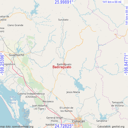
Badiraguato GPS coordinates[2]
25° 21' 54.9" North, 107° 33' 2.988" West
| Map corner | latitude | longitude |
|---|---|---|
| Upper-left | 25.99891°, | -108.25396° |
| Center: | 25.36525°, | -107.55083° |
| Lower-right: | 24.72825°, | -106.84771° |
| Map W x H: | 141.3×141.3 km | = 87.8×87.8mi |
| max Lat: | 32.7° ⇑7.7% North |
| Badiraguato: | 25.36525° |
| min Lat: | ⇓92.3% South 14.53588° |
| min Long | Badiraguato | max Long |
| -117.105° | -107.55083° | -86.73105° |
| W 5%⇐ | ⇒95% E |
Elevation
Elevation of Badiraguato is 208 m = 682 ft, and this is 1045.7 m = 3431 ft below average elevation for this country.
| Max E: |
3497 m = 11473 ft | 75.4% |
| Avg. | 1253.7 m = 4113 ft | |
| Badiraguato | 208 m = 682 ft | |
Min E: |
-1 m = -3 ft | 24.6% |
See also: Mexico elevation on elevation.city.
Geographical zone
Badiraguato is located in North temperate zone (between Tropic of Cancer and the Arctic Circle). Distance of this Northern Tropic circle is 214.4 km =133.2 mi to South.| Distance of | km | miles | from Badiraguato |
|---|---|---|---|
| North Pole | 7186.7 | 4465.6 | to North |
| Arctic Circle | 4580.8 | 2846.4 | to North |
| Tropic Cancer | 214.4 | 133.2 | to South |
| Equator | 2820.4 | 1752.5 | to South |


Nearby cities:
15 places around Badiraguato: (largest is in red/bold)
• Caitime
40.6 km =25.2 mi,  265°
265°
• Cerro Agudo
48.8 km =30.3 mi,  302°
302°
• Colonia Agrícola México (Palmitas)
48.8 km =30.3 mi,  234°
234°
• El Mezquite
42.3 km =26.3 mi,  310°
310°
• El Zapotillo
42.2 km =26.2 mi,  223°
223°
• Jesús María
32.3 km =20.1 mi,  162°
162°
• La Campana
40.4 km =25.1 mi,  183°
183°
• Mocorito
39.3 km =24.4 mi,  289°
289°
• Otatillos
21.6 km =13.4 mi,  82°
82°
• Pericos
35 km =21.7 mi,  205°
205°
• Potrero de los Sánchez (Estación Techa)
45.2 km =28.1 mi, 231°
• Rancho Viejo
34.2 km =21.3 mi, 217°
• Recoveco
45 km =28 mi,  203°
203°
• San Benito
29.2 km =18.1 mi, 312°
• Tamiapa
35.1 km =21.8 mi,  30°
30°
Sources, notices
• [Note1] Compared only with cities in Mexico existing in our database
• [Src1] Map data: © OpenStreetMap contributors (CC-BY-SA)
• [Src2] Other city data from geonames.org with taken over terms of usage.
• [Src3] Geographical zone / Annual Mean Temperature by Robert A. Rohde @ Wikipedia
