Jesús María geodata
Jesús María (Sinaloa) is a populated place; located in Mexico in America/Mazatlan (GMT-7) time zone. With population of 2,330 people, there are 3787 cities with bigger population in this country. Compared to other cities in Mexico, 91.9% of cities are located further ↓South; 94.9% of cities are located further →East and 76% of cities have higher elevation than Jesús María. Note1


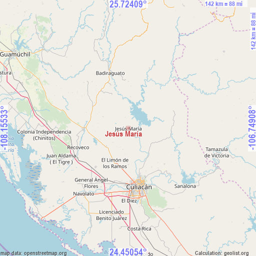
Jesús María GPS coordinates[2]
25° 5' 20.292" North, 107° 27' 7.92" West
| Map corner | latitude | longitude |
|---|---|---|
| Upper-left | 25.72409°, | -108.15533° |
| Center: | 25.08897°, | -107.4522° |
| Lower-right: | 24.45054°, | -106.74908° |
| Map W x H: | 141.6×141.6 km | = 88×88mi |
| max Lat: | 32.7° ⇑8.1% North |
| Jesús María: | 25.08897° |
| min Lat: | ⇓91.9% South 14.53588° |
| min Long | Jesús María | max Long |
| -117.105° | -107.4522° | -86.73105° |
| W 5.1%⇐ | ⇒94.9% E |
Elevation
Elevation of Jesús María is 185 m = 607 ft, and this is 1068.7 m = 3506 ft below average elevation for this country.
| Max E: |
3497 m = 11473 ft | 76% |
| Avg. | 1253.7 m = 4113 ft | |
| Jesús María | 185 m = 607 ft | |
Min E: |
-1 m = -3 ft | 24% |
See also: Mexico elevation on elevation.city.
Geographical zone
Jesús María is located in North temperate zone (between Tropic of Cancer and the Arctic Circle). Distance of this Northern Tropic circle is 183.7 km =114.1 mi to South.| Distance of | km | miles | from Jesús María |
|---|---|---|---|
| North Pole | 7217.4 | 4484.7 | to North |
| Arctic Circle | 4611.5 | 2865.5 | to North |
| Tropic Cancer | 183.7 | 114.1 | to South |
| Equator | 2789.6 | 1733.4 | to South |


Nearby cities:
15 places around Jesús María: (largest is in red/bold)
• Adolfo López Mateos (El Tamarindo)
28.1 km =17.5 mi,  220°
220°
• Agua Caliente de los Monzón
18.5 km =11.5 mi,  158°
158°
• Bacurimí
30.8 km =19.1 mi,  180°
180°
• Bellavista
30.6 km =19 mi, 181°
• Culiacancito
30.5 km =19 mi,  195°
195°
• El Limón de los Ramos
20.8 km =12.9 mi, 200°
• El Pozo
28.1 km =17.5 mi,  134°
134°
• El Tepuche
19.2 km =11.9 mi,  147°
147°
• Estación Rosales
30.8 km =19.1 mi, 204°
• La Campana
15.5 km =9.6 mi,  231°
231°
• La Limita de Itaje
31.5 km =19.6 mi, 162°
• La Palmita y Anexos (La Presita)
20 km =12.4 mi, 179°
• Pericos
24.9 km =15.5 mi,  267°
267°
• Rancho Viejo
30.9 km =19.2 mi,  276°
276°
• Recoveco
29.7 km =18.5 mi,  249°
249°
Sources, notices
• [Note1] Compared only with cities in Mexico existing in our database
• [Src1] Map data: © OpenStreetMap contributors (CC-BY-SA)
• [Src2] Other city data from geonames.org with taken over terms of usage.
• [Src3] Geographical zone / Annual Mean Temperature by Robert A. Rohde @ Wikipedia
