Naranjito de Copal geodata
Naranjito de Copal (Nayarit) is a populated place; located in Mexico in America/Mazatlan (GMT-7) time zone. With population of 520 people, there are 16208 cities with bigger population in this country. Compared to other cities in Mexico, 82% of cities are located further ↓South; 91.1% of cities are located further →East and 70.3% of cities have higher elevation than Naranjito de Copal. Note1


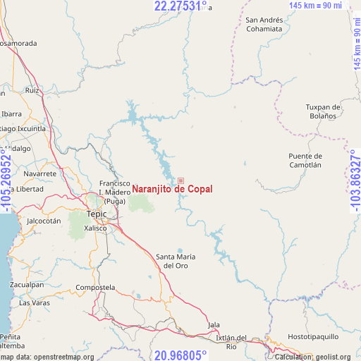
Naranjito de Copal GPS coordinates[2]
21° 37' 23.376" North, 104° 33' 59.004" West
| Map corner | latitude | longitude |
|---|---|---|
| Upper-left | 22.27531°, | -105.26952° |
| Center: | 21.62316°, | -104.56639° |
| Lower-right: | 20.96805°, | -103.86327° |
| Map W x H: | 145.4×145.4 km | = 90.3×90.3mi |
| max Lat: | 32.7° ⇑18% North |
| Naranjito de Copal: | 21.62316° |
| min Lat: | ⇓82% South 14.53588° |
| min Long | Naranjito de Co | max Long |
| -117.105° | -104.56639° | -86.73105° |
| W 8.9%⇐ | ⇒91.1% E |
Elevation
Elevation of Naranjito de Copal is 404 m = 1325 ft, and this is 849.7 m = 2788 ft below average elevation for this country.
| Max E: |
3497 m = 11473 ft | 70.3% |
| Avg. | 1253.7 m = 4113 ft | |
| Naranjito de Copal | 404 m = 1325 ft | |
Min E: |
-1 m = -3 ft | 29.7% |
See also: Mexico elevation on elevation.city.
Geographical zone
Naranjito de Copal is located in North Torrid zone (between Equator and Tropic of Cancer). Distance of this Northern Tropic circle is 201.6 km =125.3 mi to North.| Distance of | km | miles | from Naranjito de Copal |
|---|---|---|---|
| North Pole | 7602.8 | 4724.2 | to North |
| Arctic Circle | 4996.9 | 3104.9 | to North |
| Tropic Cancer | 201.6 | 125.3 | to North |
| Equator | 2404.3 | 1494 | to South |


Nearby cities:
15 places around Naranjito de Copal: (largest is in red/bold)
• Atonalisco
28.6 km =17.8 mi,  279°
279°
• Camichín de Jauja
29.9 km =18.6 mi,  234°
234°
• Cerro Blanco
27.8 km =17.3 mi,  191°
191°
• El Buruato
23.6 km =14.7 mi,  176°
176°
• El Limón
30.5 km =19 mi, 194°
• Francisco I. Madero
26.5 km =16.5 mi,  260°
260°
• Huajimic
26.8 km =16.7 mi,  75°
75°
• La Cantera
29.6 km =18.4 mi,  243°
243°
• Las Higueras
22.4 km =13.9 mi,  12°
12°
• Mojarras
22.4 km =13.9 mi, 191°
• Mora
27.4 km =17 mi,  246°
246°
• Puga
26.9 km =16.7 mi, 260°
• San Fernando
23.2 km =14.4 mi, 257°
• San Luis de Lozada
19.6 km =12.2 mi, 227°
• Santiago de Pochotitán
14.4 km =8.9 mi, 251°
Sources, notices
• [Note1] Compared only with cities in Mexico existing in our database
• [Src1] Map data: © OpenStreetMap contributors (CC-BY-SA)
• [Src2] Other city data from geonames.org with taken over terms of usage.
• [Src3] Geographical zone / Annual Mean Temperature by Robert A. Rohde @ Wikipedia
