Francisco I. Madero geodata
Francisco I. Madero (Nayarit) is a populated place; located in Mexico in America/Mazatlan (GMT-7) time zone. With population of 7,091 people, there are 1310 cities with bigger population in this country. Compared to other cities in Mexico, 81.8% of cities are located further ↓South; 91.6% of cities are located further →East and 64.1% of cities have higher elevation than Francisco I. Madero. Note1


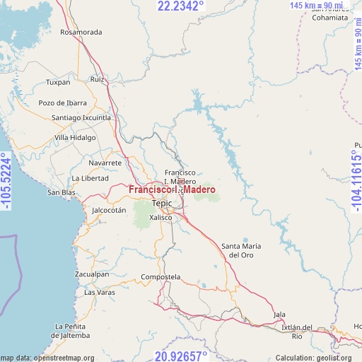
Francisco I. Madero GPS coordinates[2]
21° 34' 54.696" North, 104° 49' 9.372" West
| Map corner | latitude | longitude |
|---|---|---|
| Upper-left | 22.2342°, | -105.5224° |
| Center: | 21.58186°, | -104.81927° |
| Lower-right: | 20.92657°, | -104.11615° |
| Map W x H: | 145.4×145.4 km | = 90.3×90.3mi |
| max Lat: | 32.7° ⇑18.2% North |
| Francisco I. Madero: | 21.58186° |
| min Lat: | ⇓81.8% South 14.53588° |
| min Long | Francisco I. Ma | max Long |
| -117.105° | -104.81927° | -86.73105° |
| W 8.4%⇐ | ⇒91.6% E |
Elevation
Elevation of Francisco I. Madero is 742 m = 2434 ft, and this is 511.7 m = 1679 ft below average elevation for this country.
| Max E: |
3497 m = 11473 ft | 64.1% |
| Avg. | 1253.7 m = 4113 ft | |
| Francisco I. Madero | 742 m = 2434 ft | |
Min E: |
-1 m = -3 ft | 35.9% |
See also: Mexico elevation on elevation.city.
Geographical zone
Francisco I. Madero is located in North Torrid zone (between Equator and Tropic of Cancer). Distance of this Northern Tropic circle is 206.2 km =128.1 mi to North.| Distance of | km | miles | from Francisco I. Madero |
|---|---|---|---|
| North Pole | 7607.4 | 4727 | to North |
| Arctic Circle | 5001.5 | 3107.8 | to North |
| Tropic Cancer | 206.2 | 128.1 | to North |
| Equator | 2399.7 | 1491.1 | to South |


Nearby cities:
15 places around Francisco I. Madero: (largest is in red/bold)
• Atonalisco
9.5 km =5.9 mi,  347°
347°
• Bellavista
6.9 km =4.3 mi,  251°
251°
• Camichín de Jauja
13.1 km =8.1 mi,  171°
171°
• El Rincón
12 km =7.5 mi,  260°
260°
• El Verde
14.4 km =8.9 mi,  183°
183°
• La Cantera
8.8 km =5.5 mi, 182°
• La Fortuna
14 km =8.7 mi, 256°
• Lo de Lamedo
13.3 km =8.3 mi, 248°
• Mora
6.2 km =3.9 mi, 171°
• Puga
0.5 km =0.3 mi,  305°
305°
• San Andrés
8.1 km =5 mi,  289°
289°
• San Fernando
3.5 km =2.2 mi,  96°
96°
• San Luis de Lozada
14.7 km =9.1 mi,  126°
126°
• Santiago de Pochotitán
12.5 km =7.8 mi,  90°
90°
• Tepic
11.3 km =7 mi,  224°
224°
Sources, notices
• [Note1] Compared only with cities in Mexico existing in our database
• [Src1] Map data: © OpenStreetMap contributors (CC-BY-SA)
• [Src2] Other city data from geonames.org with taken over terms of usage.
• [Src3] Geographical zone / Annual Mean Temperature by Robert A. Rohde @ Wikipedia
