El Buruato geodata
El Buruato (Nayarit) is a populated place; located in Mexico in America/Mazatlan (GMT-7) time zone. With population of 519 people, there are 16226 cities with bigger population in this country. Compared to other cities in Mexico, 80.9% of cities are located further ↓South; 91.1% of cities are located further →East and 67.5% of cities have higher elevation than El Buruato. Note1


El Buruato GPS coordinates[2]
21° 24' 39.24" North, 104° 33' 15.228" West
| Map corner | latitude | longitude |
|---|---|---|
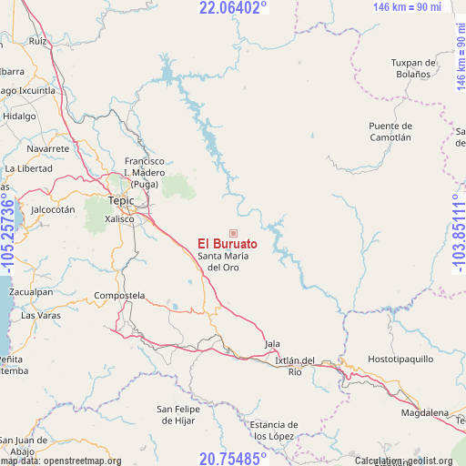
| Upper-left | 22.06402°, | -105.25736° |
| Center: | 21.4109°, | -104.55423° |
| Lower-right: | 20.75485°, | -103.85111° |
| Map W x H: | 145.6×145.6 km | = 90.5×90.5mi |
| max Lat: | 32.7° ⇑19.1% North |
| El Buruato: | 21.4109° |
| min Lat: | ⇓80.9% South 14.53588° |
| min Long | El Buruato | max Long |
| -117.105° | -104.55423° | -86.73105° |
| W 8.9%⇐ | ⇒91.1% E |
Elevation
Elevation of El Buruato is 556 m = 1824 ft, and this is 697.7 m = 2289 ft below average elevation for this country.
| Max E: |
3497 m = 11473 ft | 67.5% |
| Avg. | 1253.7 m = 4113 ft | |
| El Buruato | 556 m = 1824 ft | |
Min E: |
-1 m = -3 ft | 32.5% |
See also: Mexico elevation on elevation.city.
Geographical zone
El Buruato is located in North Torrid zone (between Equator and Tropic of Cancer). Distance of this Northern Tropic circle is 225.3 km =140 mi to North.| Distance of | km | miles | from El Buruato |
|---|---|---|---|
| North Pole | 7626.4 | 4738.8 | to North |
| Arctic Circle | 5020.5 | 3119.6 | to North |
| Tropic Cancer | 225.3 | 140 | to North |
| Equator | 2380.7 | 1479.3 | to South |


Nearby cities:
15 places around El Buruato: (largest is in red/bold)
• Cerro Blanco
7.7 km =4.8 mi,  242°
242°
• Chapalilla
26.2 km =16.3 mi,  199°
199°
• Cofradía de Acuitapilco
7.9 km =4.9 mi,  157°
157°
• El Limón
10.7 km =6.6 mi, 236°
• El Refugio
22.8 km =14.2 mi,  271°
271°
• La Labor
17.6 km =10.9 mi,  256°
256°
• Mojarras
5.9 km =3.7 mi,  286°
286°
• Naranjito de Copal
23.6 km =14.7 mi,  356°
356°
• San Leonel
16.8 km =10.4 mi,  246°
246°
• San Luis de Lozada
18.7 km =11.6 mi,  303°
303°
• Santa María del Oro
9.2 km =5.7 mi, 201°
• Santiago de Pochotitán
24.1 km =15 mi,  321°
321°
• Tequepexpan
21.8 km =13.5 mi,  184°
184°
• Trigomil
24.7 km =15.3 mi, 265°
• Zapotanito
13 km =8.1 mi,  205°
205°
Sources, notices
• [Note1] Compared only with cities in Mexico existing in our database
• [Src1] Map data: © OpenStreetMap contributors (CC-BY-SA)
• [Src2] Other city data from geonames.org with taken over terms of usage.
• [Src3] Geographical zone / Annual Mean Temperature by Robert A. Rohde @ Wikipedia
