Naica geodata
Naica (Chihuahua) is a populated place; located in Mexico in America/Chihuahua (GMT-6) time zone. With population of 4,938 people, there are 1871 cities with bigger population in this country. Compared to other cities in Mexico, 97.1% of cities are located further ↓South; 93.3% of cities are located further →East and 52.3% of cities have higher elevation than Naica. Note1


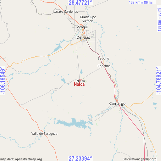
Naica GPS coordinates[2]
27° 51' 26.496" North, 105° 29' 32.388" West
| Map corner | latitude | longitude |
|---|---|---|
| Upper-left | 28.47721°, | -106.19546° |
| Center: | 27.85736°, | -105.49233° |
| Lower-right: | 27.23394°, | -104.78921° |
| Map W x H: | 138.2×138.2 km | = 85.9×85.9mi |
| max Lat: | 32.7° ⇑2.9% North |
| Naica: | 27.85736° |
| min Lat: | ⇓97.1% South 14.53588° |
| min Long | Naica | max Long |
| -117.105° | -105.49233° | -86.73105° |
| W 6.7%⇐ | ⇒93.3% E |
Elevation
Elevation of Naica is 1325 m = 4347 ft, and this is 71.3 m = 234 ft above average elevation for this country.
| Max E: |
3497 m = 11473 ft | 52.3% |
| Naica | 1325 m 4347 ft | |
| Avg. | 1253.7 m = 4113 ft | |
Min E: |
-1 m = -3 ft | 47.7% |
See also: Mexico elevation on elevation.city.
Geographical zone
Naica is located in North temperate zone (between Tropic of Cancer and the Arctic Circle). Distance of this Northern Tropic circle is 491.5 km =305.4 mi to South.| Distance of | km | miles | from Naica |
|---|---|---|---|
| North Pole | 6909.6 | 4293.4 | to North |
| Arctic Circle | 4303.7 | 2674.2 | to North |
| Tropic Cancer | 491.5 | 305.4 | to South |
| Equator | 3097.4 | 1924.6 | to South |


Nearby cities:
15 places around Naica: (largest is in red/bold)
• Colonia Campesina
31.6 km =19.6 mi,  353°
353°
• Colonia Nicolás Bravo (Kilómetro Noventa y Dos)
26.3 km =16.3 mi, 352°
• Colonia Vicente Guerrero
26.2 km =16.3 mi,  41°
41°
• Corraleño
32.3 km =20.1 mi,  99°
99°
• Estación Conchos
23.8 km =14.8 mi,  57°
57°
• Estación Saucillo
25.3 km =15.7 mi, 42°
• Estación la Cruz
30.1 km =18.7 mi, 96°
• Kilómetro Noventa y Nueve
31.2 km =19.4 mi,  343°
343°
• La Cruz
29.1 km =18.1 mi,  88°
88°
• Loma Chica
32.3 km =20.1 mi,  27°
27°
• Parritas
29.4 km =18.3 mi, 60°
• San Ignacio
32.4 km =20.1 mi,  112°
112°
• Santa Gertrudis (La Hacienda)
25 km =15.5 mi,  249°
249°
• Saucillo
27.4 km =17 mi,  45°
45°
• Valle del Toro
28.5 km =17.7 mi,  66°
66°
Sources, notices
• [Note1] Compared only with cities in Mexico existing in our database
• [Src1] Map data: © OpenStreetMap contributors (CC-BY-SA)
• [Src2] Other city data from geonames.org with taken over terms of usage.
• [Src3] Geographical zone / Annual Mean Temperature by Robert A. Rohde @ Wikipedia
