Corraleño geodata
Corraleño (Chihuahua) is a populated place; located in Mexico in America/Chihuahua (GMT-6) time zone. With population of 591 people, there are 14530 cities with bigger population in this country. Compared to other cities in Mexico, 97.1% of cities are located further ↓South; 92.2% of cities are located further →East and 54.7% of cities have higher elevation than Corraleño. Note1


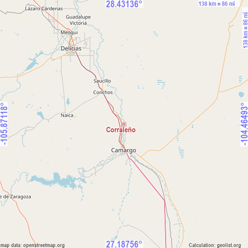
Corraleño GPS coordinates[2]
27° 48' 40.464" North, 105° 10' 4.98" West
| Map corner | latitude | longitude |
|---|---|---|
| Upper-left | 28.43136°, | -105.87118° |
| Center: | 27.81124°, | -105.16805° |
| Lower-right: | 27.18756°, | -104.46493° |
| Map W x H: | 138.3×138.3 km | = 85.9×85.9mi |
| max Lat: | 32.7° ⇑2.9% North |
| Corraleño: | 27.81124° |
| min Lat: | ⇓97.1% South 14.53588° |
| min Long | Corraleño | max Long |
| -117.105° | -105.16805° | -86.73105° |
| W 7.8%⇐ | ⇒92.2% E |
Elevation
Elevation of Corraleño is 1213 m = 3980 ft, and this is 40.7 m = 134 ft below average elevation for this country.
| Max E: |
3497 m = 11473 ft | 54.7% |
| Avg. | 1253.7 m = 4113 ft | |
| Corraleño | 1213 m = 3980 ft | |
Min E: |
-1 m = -3 ft | 45.3% |
See also: Mexico elevation on elevation.city.
Geographical zone
Corraleño is located in North temperate zone (between Tropic of Cancer and the Arctic Circle). Distance of this Northern Tropic circle is 486.4 km =302.2 mi to South.| Distance of | km | miles | from Corraleño |
|---|---|---|---|
| North Pole | 6914.7 | 4296.6 | to North |
| Arctic Circle | 4308.9 | 2677.4 | to North |
| Tropic Cancer | 486.4 | 302.2 | to South |
| Equator | 3092.3 | 1921.5 | to South |


Nearby cities:
15 places around Corraleño: (largest is in red/bold)
• Alta Vista
10.8 km =6.7 mi,  195°
195°
• Boquilla de Babisas (La Boquilla de Conchos)
37.3 km =23.2 mi,  218°
218°
• Camargo
14.8 km =9.2 mi,  181°
181°
• Colonia Vicente Guerrero
28.7 km =17.8 mi,  329°
329°
• Conchos
29.7 km =18.5 mi,  213°
213°
• Estación Conchos
21.6 km =13.4 mi, 326°
• Estación Saucillo
28 km =17.4 mi, 328°
• Estación la Cruz
2.6 km =1.6 mi,  309°
309°
• La Cruz
6.4 km =4 mi, 334°
• Loma Chica
38 km =23.6 mi, 333°
• Naica
32.3 km =20.1 mi,  279°
279°
• Parritas
20.8 km =12.9 mi,  342°
342°
• San Ignacio
7.3 km =4.5 mi,  194°
194°
• Saucillo
27.3 km =17 mi, 333°
• Valle del Toro
17.3 km =10.7 mi, 340°
Sources, notices
• [Note1] Compared only with cities in Mexico existing in our database
• [Src1] Map data: © OpenStreetMap contributors (CC-BY-SA)
• [Src2] Other city data from geonames.org with taken over terms of usage.
• [Src3] Geographical zone / Annual Mean Temperature by Robert A. Rohde @ Wikipedia
