Morcillo geodata
Morcillo (Durango) is a populated place; located in Mexico in America/Monterrey (GMT-6) time zone. With population of 885 people, there are 9853 cities with bigger population in this country. Compared to other cities in Mexico, 90.4% of cities are located further ↓South; 91.4% of cities are located further →East and 69.6% of cities have lower elevation than Morcillo. Note1


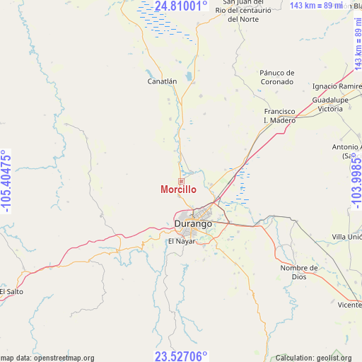
Morcillo GPS coordinates[2]
24° 10' 12.54" North, 104° 42' 5.832" West
| Map corner | latitude | longitude |
|---|---|---|
| Upper-left | 24.81001°, | -105.40475° |
| Center: | 24.17015°, | -104.70162° |
| Lower-right: | 23.52706°, | -103.9985° |
| Map W x H: | 142.7×142.7 km | = 88.7×88.7mi |
| max Lat: | 32.7° ⇑9.6% North |
| Morcillo: | 24.17015° |
| min Lat: | ⇓90.4% South 14.53588° |
| min Long | Morcillo | max Long |
| -117.105° | -104.70162° | -86.73105° |
| W 8.6%⇐ | ⇒91.4% E |
Elevation
Elevation of Morcillo is 1918 m = 6293 ft, and this is 664.3 m = 2179 ft above average elevation for this country.
| Max E: |
3497 m = 11473 ft | 30.4% |
| Morcillo | 1918 m 6293 ft | |
| Avg. | 1253.7 m = 4113 ft | |
Min E: |
-1 m = -3 ft | 69.6% |
See also: Mexico elevation on elevation.city.
Geographical zone
Morcillo is located in North temperate zone (between Tropic of Cancer and the Arctic Circle). Distance of this Northern Tropic circle is 81.5 km =50.6 mi to South.| Distance of | km | miles | from Morcillo |
|---|---|---|---|
| North Pole | 7319.6 | 4548.2 | to North |
| Arctic Circle | 4713.7 | 2929 | to North |
| Tropic Cancer | 81.5 | 50.6 | to South |
| Equator | 2687.5 | 1669.9 | to South |


Nearby cities:
15 places around Morcillo: (largest is in red/bold)
• Abraham González
17.9 km =11.1 mi,  75°
75°
• Cinco de Febrero
22.5 km =14 mi,  117°
117°
• Cinco de Mayo
15 km =9.3 mi, 120°
• Contreras
20.7 km =12.9 mi,  134°
134°
• Dolores Hidalgo
22.8 km =14.2 mi,  145°
145°
• El Nayar
22.9 km =14.2 mi,  178°
178°
• El Pueblito
22.5 km =14 mi, 184°
• El Refugio (El Conejo)
21.7 km =13.5 mi, 179°
• Gabino Santillán
23.7 km =14.7 mi, 152°
• Hidalgo
12.1 km =7.5 mi,  96°
96°
• Juan B. Ceballos
5.4 km =3.4 mi,  41°
41°
• Labor de Guadalupe
10.8 km =6.7 mi,  94°
94°
• Navacoyán
20.5 km =12.7 mi, 131°
• San Vicente de Chupaderos
5.9 km =3.7 mi,  191°
191°
• Victoria de Durango
17.2 km =10.7 mi,  164°
164°
Sources, notices
• [Note1] Compared only with cities in Mexico existing in our database
• [Src1] Map data: © OpenStreetMap contributors (CC-BY-SA)
• [Src2] Other city data from geonames.org with taken over terms of usage.
• [Src3] Geographical zone / Annual Mean Temperature by Robert A. Rohde @ Wikipedia
