Monte Escobedo geodata
Monte Escobedo (Zacatecas) is a seat of a second-order administrative division; located in Mexico in America/Mexico_City (GMT-6) time zone. With population of 3,937 people, there are 2319 cities with bigger population in this country. Compared to other cities in Mexico, 85.8% of cities are located further ↓South; 88.6% of cities are located further →East and 82.7% of cities have lower elevation than Monte Escobedo. Note1


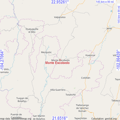
Monte Escobedo GPS coordinates[2]
22° 18' 13.032" North, 103° 34' 3.036" West
| Map corner | latitude | longitude |
|---|---|---|
| Upper-left | 22.95261°, | -104.27064° |
| Center: | 22.30362°, | -103.56751° |
| Lower-right: | 21.6516°, | -102.86439° |
| Map W x H: | 144.7×144.7 km | = 89.9×89.9mi |
| max Lat: | 32.7° ⇑14.2% North |
| Monte Escobedo: | 22.30362° |
| min Lat: | ⇓85.8% South 14.53588° |
| min Long | Monte Escobedo | max Long |
| -117.105° | -103.56751° | -86.73105° |
| W 11.4%⇐ | ⇒88.6% E |
Elevation
Elevation of Monte Escobedo is 2208 m = 7244 ft, and this is 954.3 m = 3131 ft above average elevation for this country.
| Max E: |
3497 m = 11473 ft | 17.3% |
| Monte Escobedo | 2208 m 7244 ft | |
| Avg. | 1253.7 m = 4113 ft | |
Min E: |
-1 m = -3 ft | 82.7% |
See also: Mexico elevation on elevation.city.
Geographical zone
Monte Escobedo is located in North Torrid zone (between Equator and Tropic of Cancer). Distance of this Northern Tropic circle is 126 km =78.3 mi to North.| Distance of | km | miles | from Monte Escobedo |
|---|---|---|---|
| North Pole | 7527.1 | 4677.1 | to North |
| Arctic Circle | 4921.2 | 3057.9 | to North |
| Tropic Cancer | 126 | 78.3 | to North |
| Equator | 2479.9 | 1540.9 | to South |


Nearby cities:
15 places around Monte Escobedo: (largest is in red/bold)
• Colotlán
37.5 km =23.3 mi,  124°
124°
• Huejuquilla el Alto
49.3 km =30.6 mi,  316°
316°
• Huejúcar
37.1 km =23.1 mi,  80°
80°
• Laguna Grande
16.8 km =10.4 mi,  23°
23°
• Las Golondrinas [Fraccionamiento]
39.1 km =24.3 mi, 124°
• Mezquitic
19 km =11.8 mi,  300°
300°
• San Antonio de Padua
41.8 km =26 mi, 315°
• Santa María de los Ángeles
38.1 km =23.7 mi,  112°
112°
• Temastián (La Cantera)
36.6 km =22.7 mi,  173°
173°
• Tenzompa
37.7 km =23.4 mi,  281°
281°
• Tepetongo
46.1 km =28.6 mi,  68°
68°
• Tlacosahua
41 km =25.5 mi,  94°
94°
• Totatiche
43.6 km =27.1 mi,  163°
163°
• Villa Guerrero
35.7 km =22.2 mi,  184°
184°
• Víboras
42.6 km =26.5 mi, 73°
Sources, notices
• [Note1] Compared only with cities in Mexico existing in our database
• [Src1] Map data: © OpenStreetMap contributors (CC-BY-SA)
• [Src2] Other city data from geonames.org with taken over terms of usage.
• [Src3] Geographical zone / Annual Mean Temperature by Robert A. Rohde @ Wikipedia
