Villa Guerrero geodata
Villa Guerrero (Jalisco) is a seat of a second-order administrative division; located in Mexico in America/Mexico_City (GMT-6) time zone. With population of 3,869 people, there are 2369 cities with bigger population in this country. Compared to other cities in Mexico, 84.1% of cities are located further ↓South; 88.7% of cities are located further →East and 62.8% of cities have lower elevation than Villa Guerrero. Note1


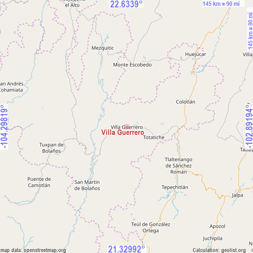
Villa Guerrero GPS coordinates[2]
21° 59' 0.276" North, 103° 35' 42.216" West
| Map corner | latitude | longitude |
|---|---|---|
| Upper-left | 22.6339°, | -104.29819° |
| Center: | 21.98341°, | -103.59506° |
| Lower-right: | 21.32992°, | -102.89194° |
| Map W x H: | 145×145 km | = 90.1×90.1mi |
| max Lat: | 32.7° ⇑15.9% North |
| Villa Guerrero: | 21.98341° |
| min Lat: | ⇓84.1% South 14.53588° |
| min Long | Villa Guerrero | max Long |
| -117.105° | -103.59506° | -86.73105° |
| W 11.3%⇐ | ⇒88.7% E |
Elevation
Elevation of Villa Guerrero is 1774 m = 5820 ft, and this is 520.3 m = 1707 ft above average elevation for this country.
| Max E: |
3497 m = 11473 ft | 37.2% |
| Villa Guerrero | 1774 m 5820 ft | |
| Avg. | 1253.7 m = 4113 ft | |
Min E: |
-1 m = -3 ft | 62.8% |
See also: Mexico elevation on elevation.city.
Geographical zone
Villa Guerrero is located in North Torrid zone (between Equator and Tropic of Cancer). Distance of this Northern Tropic circle is 161.6 km =100.4 mi to North.| Distance of | km | miles | from Villa Guerrero |
|---|---|---|---|
| North Pole | 7562.7 | 4699.2 | to North |
| Arctic Circle | 4956.8 | 3080 | to North |
| Tropic Cancer | 161.6 | 100.4 | to North |
| Equator | 2444.3 | 1518.8 | to South |


Nearby cities:
15 places around Villa Guerrero: (largest is in red/bold)
• Atolinga
23.8 km =14.8 mi,  145°
145°
• Bolaños
25.5 km =15.8 mi,  228°
228°
• Chimaltitán
29.7 km =18.5 mi,  220°
220°
• Cicacalco
41.6 km =25.8 mi,  135°
135°
• Colotlán
36.7 km =22.8 mi,  66°
66°
• El Tepec
24.3 km =15.1 mi, 229°
• Fraccionamiento Santo Santiago
40.3 km =25 mi,  123°
123°
• Las Golondrinas [Fraccionamiento]
37.7 km =23.4 mi, 68°
• Momax
29.9 km =18.6 mi,  103°
103°
• Monte Escobedo
35.7 km =22.2 mi,  4°
4°
• San Martín de Bolaños
40.3 km =25 mi,  213°
213°
• Temastián (La Cantera)
7.3 km =4.5 mi, 95°
• Tepizuac
40.1 km =24.9 mi,  186°
186°
• Tlaltenango de Sánchez Román
37.5 km =23.3 mi,  126°
126°
• Totatiche
16.7 km =10.4 mi,  111°
111°
Sources, notices
• [Note1] Compared only with cities in Mexico existing in our database
• [Src1] Map data: © OpenStreetMap contributors (CC-BY-SA)
• [Src2] Other city data from geonames.org with taken over terms of usage.
• [Src3] Geographical zone / Annual Mean Temperature by Robert A. Rohde @ Wikipedia
