Colotlán geodata
Colotlán (Jalisco) is a seat of a second-order administrative division; located in Mexico in America/Mexico_City (GMT-6) time zone. With population of 13,256 people, there are 740 cities with bigger population in this country. Compared to other cities in Mexico, 84.8% of cities are located further ↓South; 87% of cities are located further →East and 57.2% of cities have lower elevation than Colotlán. Note1


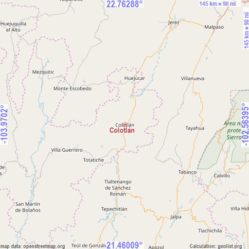
Colotlán GPS coordinates[2]
22° 6' 46.764" North, 103° 16' 1.452" West
| Map corner | latitude | longitude |
|---|---|---|
| Upper-left | 22.76288°, | -103.9702° |
| Center: | 22.11299°, | -103.26707° |
| Lower-right: | 21.46009°, | -102.56395° |
| Map W x H: | 144.9×144.9 km | = 90×90mi |
| max Lat: | 32.7° ⇑15.2% North |
| Colotlán: | 22.11299° |
| min Lat: | ⇓84.8% South 14.53588° |
| min Long | Colotlán | max Long |
| -117.105° | -103.26707° | -86.73105° |
| W 13%⇐ | ⇒87% E |
Elevation
Elevation of Colotlán is 1666 m = 5466 ft, and this is 412.3 m = 1353 ft above average elevation for this country.
| Max E: |
3497 m = 11473 ft | 42.8% |
| Colotlán | 1666 m 5466 ft | |
| Avg. | 1253.7 m = 4113 ft | |
Min E: |
-1 m = -3 ft | 57.2% |
See also: Mexico elevation on elevation.city.
Geographical zone
Colotlán is located in North Torrid zone (between Equator and Tropic of Cancer). Distance of this Northern Tropic circle is 147.2 km =91.5 mi to North.| Distance of | km | miles | from Colotlán |
|---|---|---|---|
| North Pole | 7548.3 | 4690.3 | to North |
| Arctic Circle | 4942.4 | 3071.1 | to North |
| Tropic Cancer | 147.2 | 91.5 | to North |
| Equator | 2458.7 | 1527.8 | to South |


Nearby cities:
15 places around Colotlán: (largest is in red/bold)
• El Plateado de Joaquín Amaro
26.6 km =16.5 mi,  137°
137°
• Fraccionamiento Santo Santiago
36.8 km =22.9 mi,  180°
180°
• Huejúcar
27.9 km =17.3 mi,  11°
11°
• La Encarnación
38.2 km =23.7 mi,  67°
67°
• Las Golondrinas [Fraccionamiento]
1.6 km =1 mi,  122°
122°
• Momax
21.7 km =13.5 mi,  192°
192°
• Monte Escobedo
37.5 km =23.3 mi,  304°
304°
• Santa María de los Ángeles
8 km =5 mi,  33°
33°
• Saúz de los Márquez
15.3 km =9.5 mi,  89°
89°
• Temastián (La Cantera)
30.6 km =19 mi,  240°
240°
• Tlacosahua
20.3 km =12.6 mi, 29°
• Tlaltenango de Sánchez Román
37 km =23 mi, 185°
• Totatiche
27.5 km =17.1 mi,  221°
221°
• Villa Guerrero
36.7 km =22.8 mi,  246°
246°
• Víboras
35 km =21.7 mi,  16°
16°
Sources, notices
• [Note1] Compared only with cities in Mexico existing in our database
• [Src1] Map data: © OpenStreetMap contributors (CC-BY-SA)
• [Src2] Other city data from geonames.org with taken over terms of usage.
• [Src3] Geographical zone / Annual Mean Temperature by Robert A. Rohde @ Wikipedia
