Huejúcar geodata
Huejúcar (Jalisco) is a seat of a second-order administrative division; located in Mexico in America/Mexico_City (GMT-6) time zone. With population of 3,647 people, there are 2514 cities with bigger population in this country. Compared to other cities in Mexico, 86% of cities are located further ↓South; 86.6% of cities are located further →East and 65.5% of cities have lower elevation than Huejúcar. Note1


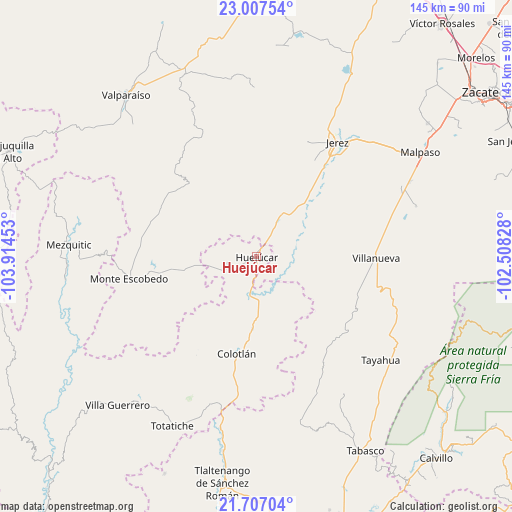
Huejúcar GPS coordinates[2]
22° 21' 31.716" North, 103° 12' 41.04" West
| Map corner | latitude | longitude |
|---|---|---|
| Upper-left | 23.00754°, | -103.91453° |
| Center: | 22.35881°, | -103.2114° |
| Lower-right: | 21.70704°, | -102.50828° |
| Map W x H: | 144.6×144.6 km | = 89.9×89.9mi |
| max Lat: | 32.7° ⇑14% North |
| Huejúcar: | 22.35881° |
| min Lat: | ⇓86% South 14.53588° |
| min Long | Huejúcar | max Long |
| -117.105° | -103.2114° | -86.73105° |
| W 13.4%⇐ | ⇒86.6% E |
Elevation
Elevation of Huejúcar is 1842 m = 6043 ft, and this is 588.3 m = 1930 ft above average elevation for this country.
| Max E: |
3497 m = 11473 ft | 34.5% |
| Huejúcar | 1842 m 6043 ft | |
| Avg. | 1253.7 m = 4113 ft | |
Min E: |
-1 m = -3 ft | 65.5% |
See also: Mexico elevation on elevation.city.
Geographical zone
Huejúcar is located in North Torrid zone (between Equator and Tropic of Cancer). Distance of this Northern Tropic circle is 119.9 km =74.5 mi to North.| Distance of | km | miles | from Huejúcar |
|---|---|---|---|
| North Pole | 7521 | 4673.3 | to North |
| Arctic Circle | 4915.1 | 3054.1 | to North |
| Tropic Cancer | 119.9 | 74.5 | to North |
| Equator | 2486.1 | 1544.8 | to South |


Nearby cities:
15 places around Huejúcar: (largest is in red/bold)
• Colotlán
27.9 km =17.3 mi,  191°
191°
• El Salto
27 km =16.8 mi,  95°
95°
• El Tigre
31.5 km =19.6 mi,  73°
73°
• Ermita de Guadalupe
31.3 km =19.4 mi,  36°
36°
• La Encarnación
32 km =19.9 mi,  113°
113°
• Laguna Grande
31.3 km =19.4 mi,  287°
287°
• Las Golondrinas [Fraccionamiento]
28.5 km =17.7 mi, 188°
• Monte Escobedo
37.1 km =23.1 mi,  260°
260°
• Santa María de los Ángeles
20.6 km =12.8 mi,  183°
183°
• Saúz de los Márquez
28.8 km =17.9 mi,  160°
160°
• Susticacán
30.2 km =18.8 mi,  22°
22°
• Tepetongo
12.7 km =7.9 mi,  29°
29°
• Tlacosahua
10.5 km =6.5 mi, 156°
• Villanueva
33.8 km =21 mi,  90°
90°
• Víboras
7.5 km =4.7 mi, 33°
Sources, notices
• [Note1] Compared only with cities in Mexico existing in our database
• [Src1] Map data: © OpenStreetMap contributors (CC-BY-SA)
• [Src2] Other city data from geonames.org with taken over terms of usage.
• [Src3] Geographical zone / Annual Mean Temperature by Robert A. Rohde @ Wikipedia
