Moctezuma geodata
Moctezuma (San Luis Potosí) is a seat of a second-order administrative division; located in Mexico in America/Mexico_City (GMT-6) time zone. With population of 4,792 people, there are 1930 cities with bigger population in this country. Compared to other cities in Mexico, 87.4% of cities are located further ↓South; 74.1% of cities are located further →East and 60.5% of cities have lower elevation than Moctezuma. Note1


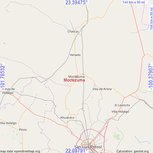
Moctezuma GPS coordinates[2]
22° 44' 52.332" North, 101° 4' 55.884" West
| Map corner | latitude | longitude |
|---|---|---|
| Upper-left | 23.39475°, | -101.78532° |
| Center: | 22.74787°, | -101.08219° |
| Lower-right: | 22.09791°, | -100.37907° |
| Map W x H: | 144.2×144.2 km | = 89.6×89.6mi |
| max Lat: | 32.7° ⇑12.6% North |
| Moctezuma: | 22.74787° |
| min Lat: | ⇓87.4% South 14.53588° |
| min Long | Moctezuma | max Long |
| -117.105° | -101.08219° | -86.73105° |
| W 25.9%⇐ | ⇒74.1% E |
Elevation
Elevation of Moctezuma is 1734 m = 5689 ft, and this is 480.3 m = 1576 ft above average elevation for this country.
| Max E: |
3497 m = 11473 ft | 39.5% |
| Moctezuma | 1734 m 5689 ft | |
| Avg. | 1253.7 m = 4113 ft | |
Min E: |
-1 m = -3 ft | 60.5% |
See also: Mexico elevation on elevation.city.
Geographical zone
Moctezuma is located in North Torrid zone (between Equator and Tropic of Cancer). Distance of this Northern Tropic circle is 76.6 km =47.6 mi to North.| Distance of | km | miles | from Moctezuma |
|---|---|---|---|
| North Pole | 7477.7 | 4646.4 | to North |
| Arctic Circle | 4871.8 | 3027.2 | to North |
| Tropic Cancer | 76.6 | 47.6 | to North |
| Equator | 2529.3 | 1571.6 | to South |


Nearby cities:
15 places around Moctezuma: (largest is in red/bold)
• Bocas
26.3 km =16.3 mi,  166°
166°
• Cerrito de Rojas
35.6 km =22.1 mi,  198°
198°
• Cerrito de Zavala
25.8 km =16 mi,  155°
155°
• Derramaderos
25 km =15.5 mi,  142°
142°
• El Zapote (Cerrito Blanco)
32.2 km =20 mi,  185°
185°
• González
20.2 km =12.6 mi,  130°
130°
• La Manta
15.5 km =9.6 mi,  151°
151°
• La Melada
32.4 km =20.1 mi, 159°
• Morados
4.9 km =3 mi,  227°
227°
• Polocote de Arriba
24 km =14.9 mi,  347°
347°
• San José del Arbolito
25.6 km =15.9 mi,  107°
107°
• Santa Gertrudis
29.1 km =18.1 mi,  235°
235°
• Santa Rita
22.5 km =14 mi,  12°
12°
• Venado
20.3 km =12.6 mi,  356°
356°
• Villa de Arista
26.7 km =16.6 mi,  116°
116°
Sources, notices
• [Note1] Compared only with cities in Mexico existing in our database
• [Src1] Map data: © OpenStreetMap contributors (CC-BY-SA)
• [Src2] Other city data from geonames.org with taken over terms of usage.
• [Src3] Geographical zone / Annual Mean Temperature by Robert A. Rohde @ Wikipedia
