La Melada geodata
La Melada (San Luis Potosí) is a populated place; located in Mexico in America/Mexico_City (GMT-6) time zone. With population of 960 people, there are 9064 cities with bigger population in this country. Compared to other cities in Mexico, 86.6% of cities are located further ↓South; 73.3% of cities are located further →East and 63.5% of cities have lower elevation than La Melada. Note1


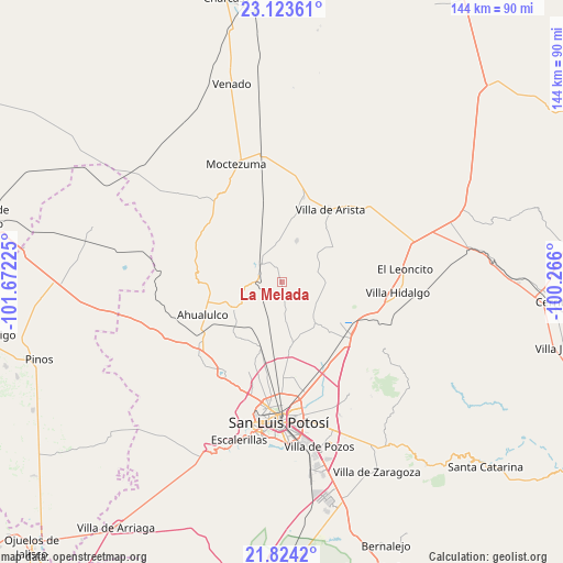
La Melada GPS coordinates[2]
22° 28' 31.548" North, 100° 58' 8.832" West
| Map corner | latitude | longitude |
|---|---|---|
| Upper-left | 23.12361°, | -101.67225° |
| Center: | 22.47543°, | -100.96912° |
| Lower-right: | 21.8242°, | -100.266° |
| Map W x H: | 144.5×144.5 km | = 89.8×89.8mi |
| max Lat: | 32.7° ⇑13.4% North |
| La Melada: | 22.47543° |
| min Lat: | ⇓86.6% South 14.53588° |
| min Long | La Melada | max Long |
| -117.105° | -100.96912° | -86.73105° |
| W 26.7%⇐ | ⇒73.3% E |
Elevation
Elevation of La Melada is 1790 m = 5873 ft, and this is 536.3 m = 1760 ft above average elevation for this country.
| Max E: |
3497 m = 11473 ft | 36.5% |
| La Melada | 1790 m 5873 ft | |
| Avg. | 1253.7 m = 4113 ft | |
Min E: |
-1 m = -3 ft | 63.5% |
See also: Mexico elevation on elevation.city.
Geographical zone
La Melada is located in North Torrid zone (between Equator and Tropic of Cancer). Distance of this Northern Tropic circle is 106.9 km =66.4 mi to North.| Distance of | km | miles | from La Melada |
|---|---|---|---|
| North Pole | 7508 | 4665.3 | to North |
| Arctic Circle | 4902.1 | 3046 | to North |
| Tropic Cancer | 106.9 | 66.4 | to North |
| Equator | 2499 | 1552.8 | to South |


Nearby cities:
15 places around La Melada: (largest is in red/bold)
• Ahualulco del Sonido Trece
21.9 km =13.6 mi,  247°
247°
• Bocas
7.2 km =4.5 mi,  311°
311°
• Cerrito de Zavala
6.9 km =4.3 mi,  353°
353°
• Colonia Emiliano Zapata (El Chamizal)
16.4 km =10.2 mi,  240°
240°
• Derramaderos
11.2 km =7 mi,  19°
19°
• Ejido de Moras
19.7 km =12.2 mi,  188°
188°
• El Peñasco
16.8 km =10.4 mi,  173°
173°
• El Zapote (Cerrito Blanco)
15 km =9.3 mi,  263°
263°
• González
17.6 km =10.9 mi,  12°
12°
• La Manta
17.2 km =10.7 mi, 345°
• Mantequilla
10.5 km =6.5 mi,  119°
119°
• Palmar Primero
17.7 km =11 mi,  228°
228°
• Puerto de Providencia
15.8 km =9.8 mi,  218°
218°
• San Pedro Ojo Zarco
17.3 km =10.7 mi,  198°
198°
• Villa de Arista
22.4 km =13.9 mi,  33°
33°
Sources, notices
• [Note1] Compared only with cities in Mexico existing in our database
• [Src1] Map data: © OpenStreetMap contributors (CC-BY-SA)
• [Src2] Other city data from geonames.org with taken over terms of usage.
• [Src3] Geographical zone / Annual Mean Temperature by Robert A. Rohde @ Wikipedia
