Villa de Arista geodata
Villa de Arista (San Luis Potosí) is a seat of a second-order administrative division; located in Mexico in America/Mexico_City (GMT-6) time zone. With population of 7,575 people, there are 1228 cities with bigger population in this country. Compared to other cities in Mexico, 87.2% of cities are located further ↓South; 72.2% of cities are located further →East and 55.9% of cities have lower elevation than Villa de Arista. Note1


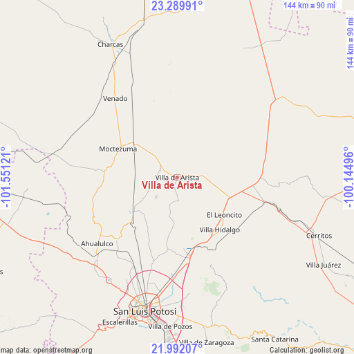
Villa de Arista GPS coordinates[2]
22° 38' 33.072" North, 100° 50' 53.088" West
| Map corner | latitude | longitude |
|---|---|---|
| Upper-left | 23.28991°, | -101.55121° |
| Center: | 22.64252°, | -100.84808° |
| Lower-right: | 21.99207°, | -100.14496° |
| Map W x H: | 144.3×144.3 km | = 89.7×89.7mi |
| max Lat: | 32.7° ⇑12.8% North |
| Villa de Arista: | 22.64252° |
| min Lat: | ⇓87.2% South 14.53588° |
| min Long | Villa de Arista | max Long |
| -117.105° | -100.84808° | -86.73105° |
| W 27.8%⇐ | ⇒72.2% E |
Elevation
Elevation of Villa de Arista is 1616 m = 5302 ft, and this is 362.3 m = 1189 ft above average elevation for this country.
| Max E: |
3497 m = 11473 ft | 44.1% |
| Villa de Arista | 1616 m 5302 ft | |
| Avg. | 1253.7 m = 4113 ft | |
Min E: |
-1 m = -3 ft | 55.9% |
See also: Mexico elevation on elevation.city.
Geographical zone
Villa de Arista is located in North Torrid zone (between Equator and Tropic of Cancer). Distance of this Northern Tropic circle is 88.3 km =54.9 mi to North.| Distance of | km | miles | from Villa de Arista |
|---|---|---|---|
| North Pole | 7489.4 | 4653.7 | to North |
| Arctic Circle | 4883.6 | 3034.5 | to North |
| Tropic Cancer | 88.3 | 54.9 | to North |
| Equator | 2517.6 | 1564.4 | to South |


Nearby cities:
15 places around Villa de Arista: (largest is in red/bold)
• Bocas
22.6 km =14 mi,  232°
232°
• Cerrito de Zavala
17.7 km =11 mi, 228°
• Derramaderos
11.8 km =7.3 mi, 227°
• El Charquito
16 km =9.9 mi,  95°
95°
• González
8.8 km =5.5 mi,  261°
261°
• La Manta
16.8 km =10.4 mi, 263°
• La Melada
22.4 km =13.9 mi,  213°
213°
• La Tapona
26.4 km =16.4 mi,  52°
52°
• Mantequilla
24 km =14.9 mi,  187°
187°
• Moctezuma
26.7 km =16.6 mi,  296°
296°
• Peyote
25 km =15.5 mi,  86°
86°
• Salitrillo
12.4 km =7.7 mi, 86°
• San José del Arbolito
4.1 km =2.5 mi,  5°
5°
• San Lorenzo
22.6 km =14 mi,  114°
114°
• Villa Hidalgo
27.6 km =17.1 mi,  140°
140°
Sources, notices
• [Note1] Compared only with cities in Mexico existing in our database
• [Src1] Map data: © OpenStreetMap contributors (CC-BY-SA)
• [Src2] Other city data from geonames.org with taken over terms of usage.
• [Src3] Geographical zone / Annual Mean Temperature by Robert A. Rohde @ Wikipedia
