Matatlán geodata
Matatlán (Jalisco) is a populated place; located in Mexico in America/Mexico_City (GMT-6) time zone. With population of 1,852 people, there are 4684 cities with bigger population in this country. Compared to other cities in Mexico, 71.8% of cities are located further ↓South; 86.3% of cities are located further →East and 54% of cities have lower elevation than Matatlán. Note1


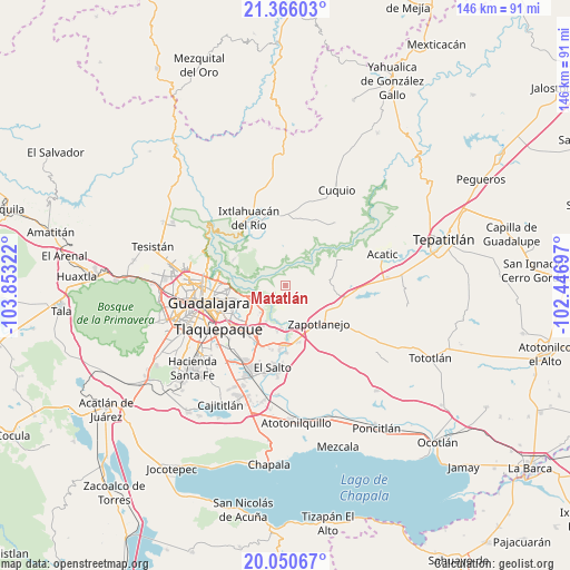
Matatlán GPS coordinates[2]
20° 42' 35.208" North, 103° 9' 0.324" West
| Map corner | latitude | longitude |
|---|---|---|
| Upper-left | 21.36603°, | -103.85322° |
| Center: | 20.70978°, | -103.15009° |
| Lower-right: | 20.05067°, | -102.44697° |
| Map W x H: | 146.3×146.3 km | = 90.9×90.9mi |
| max Lat: | 32.7° ⇑28.2% North |
| Matatlán: | 20.70978° |
| min Lat: | ⇓71.8% South 14.53588° |
| min Long | Matatlán | max Long |
| -117.105° | -103.15009° | -86.73105° |
| W 13.7%⇐ | ⇒86.3% E |
Elevation
Elevation of Matatlán is 1563 m = 5128 ft, and this is 309.3 m = 1015 ft above average elevation for this country.
| Max E: |
3497 m = 11473 ft | 46% |
| Matatlán | 1563 m 5128 ft | |
| Avg. | 1253.7 m = 4113 ft | |
Min E: |
-1 m = -3 ft | 54% |
See also: Mexico elevation on elevation.city.
Geographical zone
Matatlán is located in North Torrid zone (between Equator and Tropic of Cancer). Distance of this Northern Tropic circle is 303.2 km =188.4 mi to North.| Distance of | km | miles | from Matatlán |
|---|---|---|---|
| North Pole | 7704.4 | 4787.3 | to North |
| Arctic Circle | 5098.5 | 3168.1 | to North |
| Tropic Cancer | 303.2 | 188.4 | to North |
| Equator | 2302.7 | 1430.8 | to South |


Nearby cities:
15 places around Matatlán: (largest is in red/bold)
• Coyula
9.8 km =6.1 mi,  234°
234°
• El Vado
11.2 km =7 mi,  183°
183°
• La Laja
14.7 km =9.1 mi,  168°
168°
• La Purísima
12.3 km =7.6 mi,  93°
93°
• Los Amiales
13.5 km =8.4 mi,  218°
218°
• Mismaloya (Fraccionamiento Pedregal de Santa Martha)
11.6 km =7.2 mi,  190°
190°
• Nuevo Israel
12.2 km =7.6 mi,  264°
264°
• Paseo de las Cañadas
11 km =6.8 mi,  206°
206°
• Pueblos de la Barranca (El Maestranzo)
13.9 km =8.6 mi, 174°
• Residencias el Prado (Jardines del Prado)
7.7 km =4.8 mi,  248°
248°
• San Antonio de los Vázquez
12 km =7.5 mi,  1°
1°
• Tacotlán
12.8 km =8 mi,  341°
341°
• Tonalá
12.9 km =8 mi, 222°
• Trejos
10.6 km =6.6 mi,  332°
332°
• Zapotlanejo
13 km =8.1 mi,  138°
138°
Sources, notices
• [Note1] Compared only with cities in Mexico existing in our database
• [Src1] Map data: © OpenStreetMap contributors (CC-BY-SA)
• [Src2] Other city data from geonames.org with taken over terms of usage.
• [Src3] Geographical zone / Annual Mean Temperature by Robert A. Rohde @ Wikipedia
