Mapimí geodata
Mapimí (Durango) is a seat of a second-order administrative division; located in Mexico in America/Monterrey (GMT-6) time zone. With population of 5,623 people, there are 1657 cities with bigger population in this country. Compared to other cities in Mexico, 94.5% of cities are located further ↓South; 89.5% of cities are located further →East and 52.7% of cities have higher elevation than Mapimí. Note1


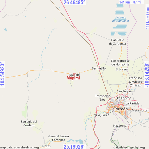
Mapimí GPS coordinates[2]
25° 50' 1.68" North, 103° 50' 45.96" West
| Map corner | latitude | longitude |
|---|---|---|
| Upper-left | 26.46495°, | -104.54923° |
| Center: | 25.8338°, | -103.8461° |
| Lower-right: | 25.19926°, | -103.14298° |
| Map W x H: | 140.7×140.7 km | = 87.4×87.4mi |
| max Lat: | 32.7° ⇑5.5% North |
| Mapimí: | 25.8338° |
| min Lat: | ⇓94.5% South 14.53588° |
| min Long | Mapimí | max Long |
| -117.105° | -103.8461° | -86.73105° |
| W 10.5%⇐ | ⇒89.5% E |
Elevation
Elevation of Mapimí is 1303 m = 4275 ft, and this is 49.3 m = 162 ft above average elevation for this country.
| Max E: |
3497 m = 11473 ft | 52.7% |
| Mapimí | 1303 m 4275 ft | |
| Avg. | 1253.7 m = 4113 ft | |
Min E: |
-1 m = -3 ft | 47.3% |
See also: Mexico elevation on elevation.city.
Geographical zone
Mapimí is located in North temperate zone (between Tropic of Cancer and the Arctic Circle). Distance of this Northern Tropic circle is 266.5 km =165.6 mi to South.| Distance of | km | miles | from Mapimí |
|---|---|---|---|
| North Pole | 7134.6 | 4433.2 | to North |
| Arctic Circle | 4528.7 | 2814 | to North |
| Tropic Cancer | 266.5 | 165.6 | to South |
| Equator | 2872.4 | 1784.8 | to South |


Nearby cities:
15 places around Mapimí: (largest is in red/bold)
• Bermejillo
23.3 km =14.5 mi,  75°
75°
• Brittingham
28.9 km =18 mi,  106°
106°
• Dinamita
22.4 km =13.9 mi,  123°
123°
• Dolores
30.7 km =19.1 mi, 113°
• Estación Noé
31.8 km =19.8 mi, 113°
• La Aurora
27.3 km =17 mi, 111°
• La Luz
32.3 km =20.1 mi,  133°
133°
• La Luz
32.6 km =20.3 mi,  104°
104°
• Manila
34.6 km =21.5 mi, 117°
• Marta
23.2 km =14.4 mi, 102°
• Palo Blanco
34.9 km =21.7 mi, 111°
• San José de Bellavista
13.9 km =8.6 mi,  73°
73°
• Santa Clara
25.4 km =15.8 mi, 96°
• Seis de Octubre
27.4 km =17 mi,  94°
94°
• Veintidós de Febrero
22.3 km =13.9 mi, 88°
Sources, notices
• [Note1] Compared only with cities in Mexico existing in our database
• [Src1] Map data: © OpenStreetMap contributors (CC-BY-SA)
• [Src2] Other city data from geonames.org with taken over terms of usage.
• [Src3] Geographical zone / Annual Mean Temperature by Robert A. Rohde @ Wikipedia
