Los Galvan geodata
Los Galvan (Guanajuato) is a populated place; located in Mexico in America/Mexico_City (GMT-6) time zone. With population of 1,364 people, there are 6370 cities with bigger population in this country. Compared to other cities in Mexico, 77.4% of cities are located further ↓South; 71.9% of cities are located further →East and 67.7% of cities have lower elevation than Los Galvan. Note1


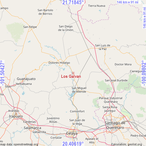
Los Galvan GPS coordinates[2]
21° 3' 49.572" North, 100° 48' 4.104" West
| Map corner | latitude | longitude |
|---|---|---|
| Upper-left | 21.71845°, | -101.50427° |
| Center: | 21.06377°, | -100.80114° |
| Lower-right: | 20.40619°, | -100.09802° |
| Map W x H: | 145.9×145.9 km | = 90.7×90.7mi |
| max Lat: | 32.7° ⇑22.6% North |
| Los Galvan: | 21.06377° |
| min Lat: | ⇓77.4% South 14.53588° |
| min Long | Los Galvan | max Long |
| -117.105° | -100.80114° | -86.73105° |
| W 28.1%⇐ | ⇒71.9% E |
Elevation
Elevation of Los Galvan is 1882 m = 6175 ft, and this is 628.3 m = 2061 ft above average elevation for this country.
| Max E: |
3497 m = 11473 ft | 32.3% |
| Los Galvan | 1882 m 6175 ft | |
| Avg. | 1253.7 m = 4113 ft | |
Min E: |
-1 m = -3 ft | 67.7% |
See also: Mexico elevation on elevation.city.
Geographical zone
Los Galvan is located in North Torrid zone (between Equator and Tropic of Cancer). Distance of this Northern Tropic circle is 263.8 km =163.9 mi to North.| Distance of | km | miles | from Los Galvan |
|---|---|---|---|
| North Pole | 7665 | 4762.8 | to North |
| Arctic Circle | 5059.1 | 3143.6 | to North |
| Tropic Cancer | 263.8 | 163.9 | to North |
| Equator | 2342.1 | 1455.3 | to South |


Nearby cities:
15 places around Los Galvan: (largest is in red/bold)
• Adjuntas del Río
9.1 km =5.7 mi,  310°
310°
• Jamaica
11.3 km =7 mi,  37°
37°
• La Cruz del Palmar
11.3 km =7 mi,  202°
202°
• La Erre
12.5 km =7.8 mi,  289°
289°
• La Grulla
9 km =5.6 mi,  60°
60°
• La Palma
4.9 km =3 mi,  153°
153°
• La Venta
6.4 km =4 mi,  12°
12°
• Las Cañas
7.8 km =4.8 mi,  96°
96°
• Lomas de San José
12.7 km =7.9 mi,  164°
164°
• Nigromante
11.5 km =7.1 mi,  169°
169°
• Palo Colorado
9.7 km =6 mi,  129°
129°
• Rancho Viejo
5.7 km =3.5 mi, 147°
• San Gabriel
8.1 km =5 mi,  334°
334°
• Santa Clara
10.1 km =6.3 mi,  319°
319°
• Tequisquiapan
2.7 km =1.7 mi, 311°
Sources, notices
• [Note1] Compared only with cities in Mexico existing in our database
• [Src1] Map data: © OpenStreetMap contributors (CC-BY-SA)
• [Src2] Other city data from geonames.org with taken over terms of usage.
• [Src3] Geographical zone / Annual Mean Temperature by Robert A. Rohde @ Wikipedia
