La Palma geodata
La Palma (Guanajuato) is a populated place; located in Mexico in America/Mexico_City (GMT-6) time zone. With population of 788 people, there are 11082 cities with bigger population in this country. Compared to other cities in Mexico, 76.8% of cities are located further ↓South; 71.7% of cities are located further →East and 67.9% of cities have lower elevation than La Palma. Note1


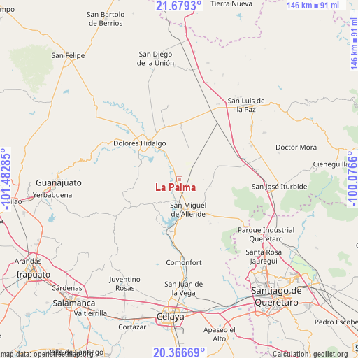
La Palma GPS coordinates[2]
21° 1' 27.984" North, 100° 46' 46.992" West
| Map corner | latitude | longitude |
|---|---|---|
| Upper-left | 21.6793°, | -101.48285° |
| Center: | 21.02444°, | -100.77972° |
| Lower-right: | 20.36669°, | -100.0766° |
| Map W x H: | 145.9×146 km | = 90.7×90.7mi |
| max Lat: | 32.7° ⇑23.2% North |
| La Palma: | 21.02444° |
| min Lat: | ⇓76.8% South 14.53588° |
| min Long | La Palma | max Long |
| -117.105° | -100.77972° | -86.73105° |
| W 28.3%⇐ | ⇒71.7% E |
Elevation
Elevation of La Palma is 1888 m = 6194 ft, and this is 634.3 m = 2081 ft above average elevation for this country.
| Max E: |
3497 m = 11473 ft | 32.1% |
| La Palma | 1888 m 6194 ft | |
| Avg. | 1253.7 m = 4113 ft | |
Min E: |
-1 m = -3 ft | 67.9% |
See also: Mexico elevation on elevation.city.
Geographical zone
La Palma is located in North Torrid zone (between Equator and Tropic of Cancer). Distance of this Northern Tropic circle is 268.2 km =166.7 mi to North.| Distance of | km | miles | from La Palma |
|---|---|---|---|
| North Pole | 7669.4 | 4765.5 | to North |
| Arctic Circle | 5063.5 | 3146.3 | to North |
| Tropic Cancer | 268.2 | 166.7 | to North |
| Equator | 2337.7 | 1452.6 | to South |


Nearby cities:
15 places around La Palma: (largest is in red/bold)
• Francisco Villa [Fraccionamiento]
10.7 km =6.6 mi,  153°
153°
• Insurgentes
10.4 km =6.5 mi,  155°
155°
• La Cieneguita
8.7 km =5.4 mi,  186°
186°
• La Cruz del Palmar
9 km =5.6 mi,  227°
227°
• La Grulla
10.4 km =6.5 mi,  32°
32°
• La Lomita
10.6 km =6.6 mi, 154°
• La Venta
10.6 km =6.6 mi,  355°
355°
• Las Cañas
6.6 km =4.1 mi,  57°
57°
• Lomas de San José
7.9 km =4.9 mi,  172°
172°
• Los Galvan
4.9 km =3 mi,  333°
333°
• Los López
10.2 km =6.3 mi,  184°
184°
• Nigromante
6.9 km =4.3 mi, 180°
• Palo Colorado
5.5 km =3.4 mi,  108°
108°
• Rancho Viejo
0.9 km =0.6 mi, 114°
• Tequisquiapan
7.5 km =4.7 mi, 325°
Sources, notices
• [Note1] Compared only with cities in Mexico existing in our database
• [Src1] Map data: © OpenStreetMap contributors (CC-BY-SA)
• [Src2] Other city data from geonames.org with taken over terms of usage.
• [Src3] Geographical zone / Annual Mean Temperature by Robert A. Rohde @ Wikipedia
