Nigromante geodata
Nigromante (Guanajuato) is a populated place; located in Mexico in America/Mexico_City (GMT-6) time zone. With population of 1,144 people, there are 7588 cities with bigger population in this country. Compared to other cities in Mexico, 75.9% of cities are located further ↓South; 71.7% of cities are located further →East and 68% of cities have lower elevation than Nigromante. Note1


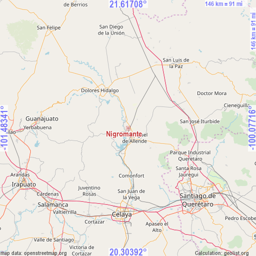
Nigromante GPS coordinates[2]
20° 57' 42.984" North, 100° 46' 49.008" West
| Map corner | latitude | longitude |
|---|---|---|
| Upper-left | 21.61708°, | -101.48341° |
| Center: | 20.96194°, | -100.78028° |
| Lower-right: | 20.30392°, | -100.07716° |
| Map W x H: | 146×146 km | = 90.7×90.7mi |
| max Lat: | 32.7° ⇑24.1% North |
| Nigromante: | 20.96194° |
| min Lat: | ⇓75.9% South 14.53588° |
| min Long | Nigromante | max Long |
| -117.105° | -100.78028° | -86.73105° |
| W 28.3%⇐ | ⇒71.7% E |
Elevation
Elevation of Nigromante is 1891 m = 6204 ft, and this is 637.3 m = 2091 ft above average elevation for this country.
| Max E: |
3497 m = 11473 ft | 32% |
| Nigromante | 1891 m 6204 ft | |
| Avg. | 1253.7 m = 4113 ft | |
Min E: |
-1 m = -3 ft | 68% |
See also: Mexico elevation on elevation.city.
Geographical zone
Nigromante is located in North Torrid zone (between Equator and Tropic of Cancer). Distance of this Northern Tropic circle is 275.2 km =171 mi to North.| Distance of | km | miles | from Nigromante |
|---|---|---|---|
| North Pole | 7676.3 | 4769.8 | to North |
| Arctic Circle | 5070.4 | 3150.6 | to North |
| Tropic Cancer | 275.2 | 171 | to North |
| Equator | 2330.7 | 1448.2 | to South |


Nearby cities:
15 places around Nigromante: (largest is in red/bold)
• Colonia San Luis Rey
5.4 km =3.4 mi,  122°
122°
• Esperanza
4.4 km =2.7 mi,  187°
187°
• Francisco Villa [Fraccionamiento]
5.5 km =3.4 mi, 118°
• Insurgentes
5.1 km =3.2 mi, 119°
• La Cieneguita
2 km =1.2 mi,  209°
209°
• La Cruz del Palmar
6.6 km =4.1 mi,  277°
277°
• La Lomita
5.3 km =3.3 mi, 119°
• La Palma
6.9 km =4.3 mi,  0°
0°
• Lomas de San José
1.5 km =0.9 mi,  127°
127°
• Los López
3.3 km =2.1 mi, 192°
• Montes de Loreto
5.8 km =3.6 mi, 125°
• Rancho Viejo
6.6 km =4.1 mi,  7°
7°
• San Miguel Viejo
6 km =3.7 mi,  180°
180°
• San Miguel de Allende
6.4 km =4 mi,  143°
143°
• Santa Cecilia
5.5 km =3.4 mi, 125°
Sources, notices
• [Note1] Compared only with cities in Mexico existing in our database
• [Src1] Map data: © OpenStreetMap contributors (CC-BY-SA)
• [Src2] Other city data from geonames.org with taken over terms of usage.
• [Src3] Geographical zone / Annual Mean Temperature by Robert A. Rohde @ Wikipedia
