Zicuicho geodata
Zicuicho (Michoacán) is a populated place; located in Mexico in America/Mexico_City (GMT-6) time zone. With population of 1,755 people, there are 4949 cities with bigger population in this country. Compared to other cities in Mexico, 50.6% of cities are located further ↑North; 83.1% of cities are located further →East and 86.4% of cities have lower elevation than Zicuicho. Note1


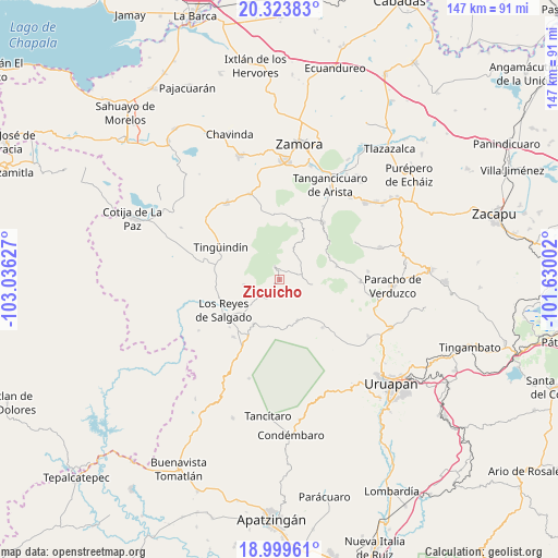
Zicuicho GPS coordinates[2]
19° 39' 47.124" North, 102° 19' 59.304" West
| Map corner | latitude | longitude |
|---|---|---|
| Upper-left | 20.32383°, | -103.03627° |
| Center: | 19.66309°, | -102.33314° |
| Lower-right: | 18.99961°, | -101.63002° |
| Map W x H: | 147.2×147.2 km | = 91.5×91.5mi |
| max Lat: | 32.7° ⇑50.6% North |
| Zicuicho: | 19.66309° |
| min Lat: | ⇓49.4% South 14.53588° |
| min Long | Zicuicho | max Long |
| -117.105° | -102.33314° | -86.73105° |
| W 16.9%⇐ | ⇒83.1% E |
Elevation
Elevation of Zicuicho is 2294 m = 7526 ft, and this is 1040.3 m = 3413 ft above average elevation for this country.
| Max E: |
3497 m = 11473 ft | 13.6% |
| Zicuicho | 2294 m 7526 ft | |
| Avg. | 1253.7 m = 4113 ft | |
Min E: |
-1 m = -3 ft | 86.4% |
See also: Mexico elevation on elevation.city.
Geographical zone
Zicuicho is located in North Torrid zone (between Equator and Tropic of Cancer). Distance of this Northern Tropic circle is 419.6 km =260.7 mi to North.| Distance of | km | miles | from Zicuicho |
|---|---|---|---|
| North Pole | 7820.7 | 4859.6 | to North |
| Arctic Circle | 5214.8 | 3240.3 | to North |
| Tropic Cancer | 419.6 | 260.7 | to North |
| Equator | 2186.3 | 1358.5 | to South |


Nearby cities:
15 places around Zicuicho: (largest is in red/bold)
• Atapán
9.7 km =6 mi,  261°
261°
• Chaniro (Xhaniro)
11.8 km =7.3 mi,  293°
293°
• Charapán
8.6 km =5.3 mi,  98°
98°
• Cherato
4.2 km =2.6 mi,  208°
208°
• Corupo
11.9 km =7.4 mi,  120°
120°
• J. Jesús Díaz Tzirio
13.3 km =8.3 mi,  329°
329°
• La Palma
6.6 km =4.1 mi,  182°
182°
• La Tinaja
10 km =6.2 mi,  313°
313°
• La Zarzamora
9.5 km =5.9 mi,  297°
297°
• Nuevo Zirosto
12.9 km =8 mi,  186°
186°
• Pamatácuaro
3.5 km =2.2 mi,  337°
337°
• San Benito
5 km =3.1 mi,  13°
13°
• San Isidro
9.3 km =5.8 mi,  23°
23°
• Urengüitiro (San Martín)
10.1 km =6.3 mi, 17°
• Zacán
11.8 km =7.3 mi,  156°
156°
Sources, notices
• [Note1] Compared only with cities in Mexico existing in our database
• [Src1] Map data: © OpenStreetMap contributors (CC-BY-SA)
• [Src2] Other city data from geonames.org with taken over terms of usage.
• [Src3] Geographical zone / Annual Mean Temperature by Robert A. Rohde @ Wikipedia
