Pamatácuaro geodata
Pamatácuaro (Michoacán) is a populated place; located in Mexico in America/Mexico_City (GMT-6) time zone. With population of 3,064 people, there are 2940 cities with bigger population in this country. Compared to other cities in Mexico, 50.2% of cities are located further ↓South; 83.2% of cities are located further →East and 90.3% of cities have lower elevation than Pamatácuaro. Note1


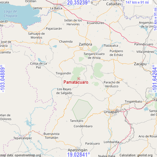
Pamatácuaro GPS coordinates[2]
19° 41' 30.372" North, 102° 20' 44.736" West
| Map corner | latitude | longitude |
|---|---|---|
| Upper-left | 20.35239°, | -103.04889° |
| Center: | 19.69177°, | -102.34576° |
| Lower-right: | 19.02841°, | -101.64264° |
| Map W x H: | 147.2×147.2 km | = 91.5×91.5mi |
| max Lat: | 32.7° ⇑49.8% North |
| Pamatácuaro: | 19.69177° |
| min Lat: | ⇓50.2% South 14.53588° |
| min Long | Pamatácuaro | max Long |
| -117.105° | -102.34576° | -86.73105° |
| W 16.8%⇐ | ⇒83.2% E |
Elevation
Elevation of Pamatácuaro is 2419 m = 7936 ft, and this is 1165.3 m = 3823 ft above average elevation for this country.
| Max E: |
3497 m = 11473 ft | 9.7% |
| Pamatácuaro | 2419 m 7936 ft | |
| Avg. | 1253.7 m = 4113 ft | |
Min E: |
-1 m = -3 ft | 90.3% |
See also: Mexico elevation on elevation.city.
Geographical zone
Pamatácuaro is located in North Torrid zone (between Equator and Tropic of Cancer). Distance of this Northern Tropic circle is 416.4 km =258.7 mi to North.| Distance of | km | miles | from Pamatácuaro |
|---|---|---|---|
| North Pole | 7817.5 | 4857.6 | to North |
| Arctic Circle | 5211.7 | 3238.4 | to North |
| Tropic Cancer | 416.4 | 258.7 | to North |
| Equator | 2189.5 | 1360.5 | to South |


Nearby cities:
15 places around Pamatácuaro: (largest is in red/bold)
• Atapán
9.4 km =5.8 mi,  240°
240°
• Chaniro (Xhaniro)
9.6 km =6 mi,  279°
279°
• Charapán
10.8 km =6.7 mi,  114°
114°
• Cherato
6.9 km =4.3 mi,  185°
185°
• Corupo
14.8 km =9.2 mi,  128°
128°
• J. Jesús Díaz Tzirio
9.9 km =6.2 mi,  327°
327°
• La Palma
9.9 km =6.2 mi,  174°
174°
• La Tinaja
7 km =4.3 mi,  301°
301°
• La Zarzamora
7.2 km =4.5 mi, 279°
• San Benito
3 km =1.9 mi,  55°
55°
• San Isidro
7.3 km =4.5 mi,  43°
43°
• Tingüindín
15.1 km =9.4 mi,  290°
290°
• Urengüitiro (San Martín)
7.8 km =4.8 mi,  34°
34°
• Zacán
15.3 km =9.5 mi,  156°
156°
• Zicuicho
3.5 km =2.2 mi, 157°
Sources, notices
• [Note1] Compared only with cities in Mexico existing in our database
• [Src1] Map data: © OpenStreetMap contributors (CC-BY-SA)
• [Src2] Other city data from geonames.org with taken over terms of usage.
• [Src3] Geographical zone / Annual Mean Temperature by Robert A. Rohde @ Wikipedia
