El Granjeno geodata
El Granjeno (Querétaro) is a populated place; located in Mexico in America/Mexico_City (GMT-6) time zone. With population of 599 people, there are 14365 cities with bigger population in this country. Compared to other cities in Mexico, 66.1% of cities are located further ↓South; 67.7% of cities are located further →East and 79.8% of cities have lower elevation than El Granjeno. Note1


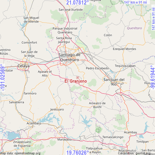
El Granjeno GPS coordinates[2]
20° 25' 14.16" North, 100° 19' 21.216" West
| Map corner | latitude | longitude |
|---|---|---|
| Upper-left | 21.07812°, | -101.02569° |
| Center: | 20.4206°, | -100.32256° |
| Lower-right: | 19.76026°, | -99.61944° |
| Map W x H: | 146.5×146.5 km | = 91×91mi |
| max Lat: | 32.7° ⇑33.9% North |
| El Granjeno: | 20.4206° |
| min Lat: | ⇓66.1% South 14.53588° |
| min Long | El Granjeno | max Long |
| -117.105° | -100.32256° | -86.73105° |
| W 32.3%⇐ | ⇒67.7% E |
Elevation
Elevation of El Granjeno is 2135 m = 7005 ft, and this is 881.3 m = 2891 ft above average elevation for this country.
| Max E: |
3497 m = 11473 ft | 20.2% |
| El Granjeno | 2135 m 7005 ft | |
| Avg. | 1253.7 m = 4113 ft | |
Min E: |
-1 m = -3 ft | 79.8% |
See also: Mexico elevation on elevation.city.
Geographical zone
El Granjeno is located in North Torrid zone (between Equator and Tropic of Cancer). Distance of this Northern Tropic circle is 335.4 km =208.4 mi to North.| Distance of | km | miles | from El Granjeno |
|---|---|---|---|
| North Pole | 7736.5 | 4807.2 | to North |
| Arctic Circle | 5130.6 | 3188 | to North |
| Tropic Cancer | 335.4 | 208.4 | to North |
| Equator | 2270.6 | 1410.9 | to South |


Nearby cities:
15 places around El Granjeno: (largest is in red/bold)
• Apapátaro
7.1 km =4.4 mi,  317°
317°
• Buenavista
6.7 km =4.2 mi,  236°
236°
• Ceja de Bravo
8.8 km =5.5 mi, 237°
• El Milagro
6.6 km =4.1 mi,  335°
335°
• El Vegil
3.1 km =1.9 mi,  292°
292°
• Guadalupe Primero
7.2 km =4.5 mi,  15°
15°
• Huimilpan
7.2 km =4.5 mi,  138°
138°
• Huitrón
6.5 km =4 mi,  218°
218°
• La Ceja
7.5 km =4.7 mi,  126°
126°
• Lagunillas
5.1 km =3.2 mi,  34°
34°
• Las Taponas
6.4 km =4 mi,  266°
266°
• Puerta de San Rafael
8.5 km =5.3 mi,  279°
279°
• San José Tepuzas
9.2 km =5.7 mi, 216°
• San Rafael
8.3 km =5.2 mi,  295°
295°
• Santa Teresa
8.5 km =5.3 mi,  14°
14°
Sources, notices
• [Note1] Compared only with cities in Mexico existing in our database
• [Src1] Map data: © OpenStreetMap contributors (CC-BY-SA)
• [Src2] Other city data from geonames.org with taken over terms of usage.
• [Src3] Geographical zone / Annual Mean Temperature by Robert A. Rohde @ Wikipedia
