Jícamas geodata
Jícamas (Guanajuato) is a populated place; located in Mexico in America/Mexico_City (GMT-6) time zone. With population of 1,623 people, there are 5331 cities with bigger population in this country. Compared to other cities in Mexico, 63.1% of cities are located further ↓South; 76.1% of cities are located further →East and 66.4% of cities have lower elevation than Jícamas. Note1


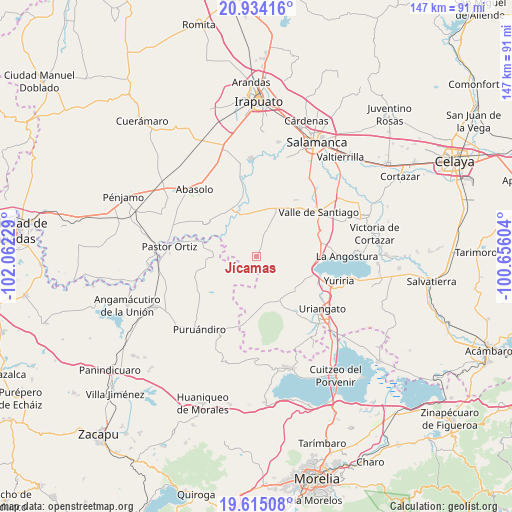
Jícamas GPS coordinates[2]
20° 16' 33.672" North, 101° 21' 32.976" West
| Map corner | latitude | longitude |
|---|---|---|
| Upper-left | 20.93416°, | -102.06229° |
| Center: | 20.27602°, | -101.35916° |
| Lower-right: | 19.61508°, | -100.65604° |
| Map W x H: | 146.7×146.7 km | = 91.2×91.2mi |
| max Lat: | 32.7° ⇑36.9% North |
| Jícamas: | 20.27602° |
| min Lat: | ⇓63.1% South 14.53588° |
| min Long | Jícamas | max Long |
| -117.105° | -101.35916° | -86.73105° |
| W 23.9%⇐ | ⇒76.1% E |
Elevation
Elevation of Jícamas is 1860 m = 6102 ft, and this is 606.3 m = 1989 ft above average elevation for this country.
| Max E: |
3497 m = 11473 ft | 33.6% |
| Jícamas | 1860 m 6102 ft | |
| Avg. | 1253.7 m = 4113 ft | |
Min E: |
-1 m = -3 ft | 66.4% |
See also: Mexico elevation on elevation.city.
Geographical zone
Jícamas is located in North Torrid zone (between Equator and Tropic of Cancer). Distance of this Northern Tropic circle is 351.4 km =218.3 mi to North.| Distance of | km | miles | from Jícamas |
|---|---|---|---|
| North Pole | 7752.6 | 4817.2 | to North |
| Arctic Circle | 5146.7 | 3198 | to North |
| Tropic Cancer | 351.4 | 218.3 | to North |
| Equator | 2254.5 | 1400.9 | to South |


Nearby cities:
15 places around Jícamas: (largest is in red/bold)
• Chamacuero
8.6 km =5.3 mi,  211°
211°
• El Pilar
5.9 km =3.7 mi,  229°
229°
• El Tigre
10.5 km =6.5 mi,  115°
115°
• Joconoxtle
8.2 km =5.1 mi, 118°
• Laguna Prieta
6.6 km =4.1 mi,  169°
169°
• Lagunilla de Mogotes
10.5 km =6.5 mi,  77°
77°
• Las Cañas
6.5 km =4 mi,  289°
289°
• Las Letras
9.2 km =5.7 mi,  237°
237°
• Las Sanguijuelas
7 km =4.3 mi,  258°
258°
• Los Martínez
4.4 km =2.7 mi,  313°
313°
• Los Reyes
9.1 km =5.7 mi,  224°
224°
• Palo Alto
6.9 km =4.3 mi, 118°
• Providencia de Calera
10.7 km =6.6 mi,  197°
197°
• Salitre de Aguilares
9.9 km =6.2 mi,  297°
297°
• Tejocote de Calera
11.5 km =7.1 mi, 200°
Sources, notices
• [Note1] Compared only with cities in Mexico existing in our database
• [Src1] Map data: © OpenStreetMap contributors (CC-BY-SA)
• [Src2] Other city data from geonames.org with taken over terms of usage.
• [Src3] Geographical zone / Annual Mean Temperature by Robert A. Rohde @ Wikipedia
